Home
Weather New York
WeatherRadar
RainRadar
TemperatureRadar
WindRadar
LightningRadar
Weather News
Editor's Pick
Discover the app
Weather widget
Contact us
Apps
Career
    Home / Editor's Pick /

    +150 acre brush fire: Large smoke plume affects parts of Miami

04:01 PM
April 15, 2024

+150 acre brush fire
Large smoke plume affects parts of Miami

Recommended external content from YouTube

We need your consent to show content from YouTube. You can withdraw your consent at any time.
I agree that content from YouTube will be displayed to me.
Privacy policy

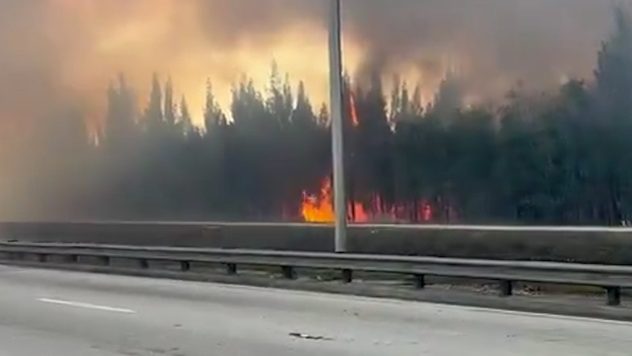
Over the weekend, a large brush fire broke out in the western region of Miami-Dade County and engulfed some largely populated cities with dense smoke. Will weather help authorities finish containing the fire?

As of Monday morning, the large brush fire happening over western Miami-Dade County is 45 percent contained, according to the Florida Forest Service. The fire started Sunday afternoon and by the late afternoon on Sunday came close to structures located over Southwest Miami-Dade, specifically SW 8th Street, which was closed in both directions for several hours. At one point on Sunday, the only thing coming between the fire and home/business was a canal and 8th Street.

Wildifre in Miami-Dade

Florida Forest Service crews worked on containing the wildfire all night, joining forces with Miami-Dade Fire Rescue, which upgraded the fire to a third-alarm fire so that more units could come together to battle.

When is wildfire season?

Florida's wildfire season goes year-round, but it peaks between April and June.

Residents of Kendall, Sweetwater, western Hialeah, and Doral could still be dealing with hazy conditions, although winds coming from the east will be guiding the dense smoke away from highly populated areas and onto the Everglades.

Still, residents, especially those with respiratory issues, are urged to stay indoors and make sure that the air conditioning is recirculating at home. Visibility will be likely obstructed at nighttime once air subsides again and the smoke becomes denser, staying like this into the early morning on Tuesday, especially if it is not contained completely today.

The weather and the fire

Winds will continue to be mainly from the east, strong at times, which will not help the firefighters battle the flames. Gusts could reach 20 mph at times. Humidity is increasing, but still not enough to produce showers. Conditions will remain mostly rain-free at least through Thursday across South Florida, with temperatures around average for this time of the year, in the low to mid-80s.

Irene Sans
More on the topic
Hawaii's second 2026 hurricane impact. Hurricane Lowell. . . Tuesday, September 8, 2026
Tuesday, September 8, 2026

Hurricane Lowell

Hawaii's second 2026 hurricane impact
Meteorological vs astronomical autumn. Season start date. . . Tuesday, September 1, 2026
Tuesday, September 1, 2026

Season start date

Meteorological vs astronomical autumn
Hurricane Polo remains dangerous. Active Pacific. . . Thursday, September 24, 2026
Thursday, September 24, 2026

Active Pacific

Hurricane Polo remains dangerous
All weather news
This might also interest you
Autumn cold front arrives. October cooldown spreads. . . Friday, October 2, 2026
Cold front brings cooler temperatures.
Friday, October 2, 2026

October cooldown spreads

Autumn cold front arrives
Spring Tides: Flooding, Road Closures. Happening along coasts. . . Tuesday, September 29, 2026
Tuesday, September 29, 2026

Happening along coasts

Spring Tides: Flooding, Road Closures
October astro outlook. Look up!. . . Saturday, October 3, 2026
Star gazing - Astro outlook
Saturday, October 3, 2026

Look up!

October astro outlook
All articles
Weather & Radar

Weather & Radar is also available on

Google Play StoreApp Store

Company

Contact us Privacy policy Legal info Accessibility statement

Services

Uploader

Socials

instagramfacebookthreadslinkList