Home
Weather New York
WeatherRadar
RainRadar
TemperatureRadar
WindRadar
LightningRadar
Weather News
Editor's Pick
Discover the app
Weather widget
Contact us
Apps
Career
    Home / Weather News /

    Strongest solar flare in nearly a decade: active week for our sun

10:00 PM
May 15, 2024

Active week for our sun
Strongest solar flare in nearly a decade

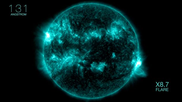
Solar flare
© NASA

On Tuesday, the sun released the largest solar flare in seven years. This comes after a very busy week that brought a generational aurora display as far south as Florida.

A powerful solar flare erupted from the sun on Tuesday. It was the largest solar flare detected since 2017 and also by far the biggest of the sun's current 11-year solar cycle.

Privacy policy

The eruption followed last week's solar flares that sent coronal mass ejections (CMEs) hurtling toward Earth over the weekend. These CMEs produced the strongest geomagnetic storm in more than two decades. Spectacular auroras were seen as far south as Florida.

Spectacular auroras over the weekendread more

Tuesday's solar flare occurred around 1 p.m. Eastern time and was rated an X-class flare, the most powerful kind. Solar flares are ranked by alphabetical classes: A-class, the smallest; and B, C, M and X-class. Tuesday's flare was an X8.7, meaning it was on the stronger end of the X-class spectrum, which ranges from 1 to 9.

While this flare was very powerful, it won't produce a repeat of this past weekend's dazzling display of northern lights. This flare originated on the sun’s western side away from Earth. Any CMEs from this flare are unlikely to produce a geomagnetic storm heading toward Earth.

More on the topic
Meteorological summer is here!. Bye, spring!. . . Monday, June 1, 2026
Monday, June 1, 2026

Bye, spring!

Meteorological summer is here!
Super Typhoon Bavi threatens Taiwan. 155 mph winds. . Weather Videos. Wednesday, July 8, 2026
The image shows an intense tropical cyclone over the western Pacific, east of Taiwan and the Philippines. The centre of the system is depicted as a light purple and white vortex with a clearly visible eye, surrounded by a ring of red and orange areas indicating the strongest wind speeds. A white arrow marks the typhoon’s predicted track towards the north-west, in the direction of Taiwan. To the west of the storm lie the Philippines, with the cities of Manila and Cebu; to the north of these lies Taiwan, with Taipei. Further west, the Chinese coast, including Hong Kong, and parts of Vietnam can be seen. The coloured wind map shows predominantly green areas outside the storm’s core, indicating significantly weaker winds. White streamlines illustrate the typhoon’s anti-clockwise circulation in the Northern Hemisphere. The highest wind speeds are concentrated around the eye of the cyclone.
Weather VideosWednesday, July 8, 2026

155 mph winds

Super Typhoon Bavi threatens Taiwan
Rip currents & safety tips. As more head to the coast. . . Saturday, July 25, 2026
rip current
Saturday, July 25, 2026

As more head to the coast

Rip currents & safety tips
All weather news
This might also interest you
August starts blazing hot. Weekend preview. . . Thursday, July 30, 2026
Triple digit Saturday for the Mountain West.
Thursday, July 30, 2026

Weekend preview

August starts blazing hot
Wildfire smoke on the WeatherRadar. Air quality concerns. . . Tuesday, August 4, 2026
Tuesday, August 4, 2026

Air quality concerns

Wildfire smoke on the WeatherRadar
Intense rain for the Northeast. Flooding possible. . . Tuesday, July 28, 2026
Tuesday, July 28, 2026

Flooding possible

Intense rain for the Northeast
All articles
Weather & Radar

Weather & Radar is also available on

Google Play StoreApp Store

Company

Contact us Privacy policy Legal info Accessibility statement

Services

Uploader

Socials

instagramfacebookthreadslinkList