Home
Weather New York
WeatherRadar
RainRadar
TemperatureRadar
WindRadar
LightningRadar
Weather News
Editor's Pick
Discover the app
Weather widget
Contact us
Apps
Career
    Home / Weather News /

    500 miles of ice: Dangerous ice storm from the Plains to Midwest

03:23 PM
January 22, 2024

500 miles of ice
Ice storm from the Plains to the Midwest

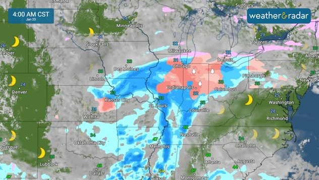
A wintry mess stretches from the Southern Plains into the Midwest Monday morning, with significant freezing rain and ice snarling travel.

The WeatherRadar shows a messy morning across much of the nation's midsection where a plume of moisture is interacting with arctic air. Snow, sleet, and ice stretch across Oklahoma, Kansas, Arkansas, and Missouri, where the moisture is meeting up with frigid air at the surface.

The plume of moisture will work its way northeast throughout Monday, spreading freezing rain and sleet up into the Midwest and Great Lakes by tonight. A glaze of ice or more will stretch all the way from northern Texas into Michigan, where winter weather advisories are in place. Ice storm warnings are in effect across parts of eastern Oklahoma, northwestern Arkansas, and south-central Missouri, where up to half an inch of ice is possible.

Freezing rain has made travel difficult to impossible in cities like Tulsa, Okla., Fayetteville, and Fort Smith, Ark., on Monday morning. The good news is that warmer temperatures and rain will help improve conditions across the Plains and mid-South Monday afternoon.

As the warmer air moves in this afternoon, the ice threat will shift north. Ice and snow will develop across the Midwest and Great Lakes Monday night into Tuesday morning. Anywhere from a glaze of ice to up to four-tenths of an inch will be possible in the Midwest, with up to an inch of snow. Travel trouble is likely in cities like St. Louis, Springfield, Ill., Chicago, South Bend, Ind., and Indianapolis.

Tuesday morning

The Upper Great Lakes will see mainly snow, with up to four inches in the forecast. Before heading out, check conditions on the WeatherRadar and make sure you have a winter weather emergency kit in your vehicle.

More on the topic
What are weather fronts?. Weather explained. . . Sunday, August 23, 2026
Image of a temperature radar showing a clear distinction between a warm and cold air mass separated by a cold front.
Sunday, August 23, 2026

Weather explained

What are weather fronts?
Super Typhoon Bavi threatens Taiwan. 155 mph winds. . Weather Videos. Wednesday, July 8, 2026
The image shows an intense tropical cyclone over the western Pacific, east of Taiwan and the Philippines. The centre of the system is depicted as a light purple and white vortex with a clearly visible eye, surrounded by a ring of red and orange areas indicating the strongest wind speeds. A white arrow marks the typhoon’s predicted track towards the north-west, in the direction of Taiwan. To the west of the storm lie the Philippines, with the cities of Manila and Cebu; to the north of these lies Taiwan, with Taipei. Further west, the Chinese coast, including Hong Kong, and parts of Vietnam can be seen. The coloured wind map shows predominantly green areas outside the storm’s core, indicating significantly weaker winds. White streamlines illustrate the typhoon’s anti-clockwise circulation in the Northern Hemisphere. The highest wind speeds are concentrated around the eye of the cyclone.
Weather VideosWednesday, July 8, 2026

155 mph winds

Super Typhoon Bavi threatens Taiwan
High pressure & extreme heat. Why & how does it work?. . . Sunday, July 12, 2026
Sunday, July 12, 2026

Why & how does it work?

High pressure & extreme heat
All weather news
This might also interest you
Be ready for tropical activity. Tips & tools. . . Saturday, August 29, 2026
Track hurricanes with the WeatherRadar
Saturday, August 29, 2026

Tips & tools

Be ready for tropical activity
Useful tips when driving in the rain. Flood safety. . . Sunday, August 30, 2026
Sunday, August 30, 2026

Flood safety

Useful tips when driving in the rain
Taste of autumn on the way. Heatwave shifts. . . Friday, August 28, 2026
Friday, August 28, 2026

Heatwave shifts

Taste of autumn on the way
All articles
Weather & Radar

Weather & Radar is also available on

Google Play StoreApp Store

Company

Contact us Privacy policy Legal info Accessibility statement

Services

Uploader

Socials

instagramfacebookthreadslinkList