Home
Weather New York
WeatherRadar
RainRadar
TemperatureRadar
WindRadar
LightningRadar
Weather News
Editor's Pick
Discover the app
Weather widget
Contact us
Apps
Career
    Home / Weather News /

    1,000-mile difference - Desert Southwest heat for the Dakotas

12:25 PM
July 13, 2026

1,000-mile difference
Desert Southwest heat for the Dakotas

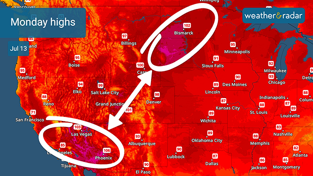
Monday's high temperature forecast is similar for both the Desert Southwest and the Dakotas.

The Dakotas and the Desert Southwest have something in common: triple-digit heat. An intense heat wave set up shop over the weekend, and it's still bringing record-breaking temperatures as far north as the Canadian border.

Check when the highest temps occurread more

It's certainly not the desert, but the northern Plains have a strong high-pressure ridge over them, circulating the heat out of the Southwest over land that usually averages out in the low 80s in July. The high temperatures aren't the main player, either. The 'feels like' temperatures reached 110 over the weekend, thanks to the humidity.

Privacy policy

The forecast shows International Falls, Minn., reaching into the mid-90s on Monday, July 13. Should it reach past 93 degrees, a record set in 1983 will be broken. Records from 2003 are also on the chopping block in Bismarck, N.D., and Rapid City, S.D., today, should highs reach 100 and 105, respectively.

The TemperatureRadar shows similar temperatures impacting both the Desert Southwest and the Dakotas through Wednesday before the ridge shifts east, bringing triple-digit heat to lucky residents in the Midwest and Mid-Atlantic.

Becca Parker
More on the topic
Super Typhoon Near the Philippines. Gusts up to 155. . . Tuesday, June 23, 2026
Tuesday, June 23, 2026

Gusts up to 155

Super Typhoon Near the Philippines
Waterspouts possible, what are they?. They can be dangerous. . . Saturday, July 11, 2026
Waterspouts weatherradar.
Saturday, July 11, 2026

They can be dangerous

Waterspouts possible, what are they?
Super Typhoon Bavi threatens Taiwan. 155 mph winds. . Weather Videos. Wednesday, July 8, 2026
The image shows an intense tropical cyclone over the western Pacific, east of Taiwan and the Philippines. The centre of the system is depicted as a light purple and white vortex with a clearly visible eye, surrounded by a ring of red and orange areas indicating the strongest wind speeds. A white arrow marks the typhoon’s predicted track towards the north-west, in the direction of Taiwan. To the west of the storm lie the Philippines, with the cities of Manila and Cebu; to the north of these lies Taiwan, with Taipei. Further west, the Chinese coast, including Hong Kong, and parts of Vietnam can be seen. The coloured wind map shows predominantly green areas outside the storm’s core, indicating significantly weaker winds. White streamlines illustrate the typhoon’s anti-clockwise circulation in the Northern Hemisphere. The highest wind speeds are concentrated around the eye of the cyclone.
Weather VideosWednesday, July 8, 2026

155 mph winds

Super Typhoon Bavi threatens Taiwan
All weather news
This might also interest you
Fireworks and Air Quality. Smoke and pollution. . . Saturday, July 4, 2026
Saturday, July 4, 2026

Smoke and pollution

Fireworks and Air Quality
Lightning season in full bloom. Staying safe this summer. . . Monday, July 6, 2026
Monday, July 6, 2026

Staying safe this summer

Lightning season in full bloom
Slow-moving storms and heavy rain. What to look for. . . Monday, July 6, 2026
Monday, July 6, 2026

What to look for

Slow-moving storms and heavy rain
All articles
Weather & Radar

Weather & Radar is also available on

Google Play StoreApp Store

Company

Contact us Privacy policy Legal info Accessibility statement

Services

Uploader

Socials

instagramfacebookthreadslinkList