Home
Weather New York
WeatherRadar
RainRadar
TemperatureRadar
WindRadar
LightningRadar
Weather News
Editor's Pick
Discover the app
Weather widget
Contact us
Apps
Career
    Home / Weather News /

    A temperature story - Winds off the water

04:33 PM
May 29, 2026

A temperature story
Winds off the water

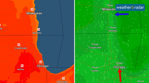
Wind direction is impacting the temperatures along western Lake Michigan's coast.
Wind direction is impacting the temperatures along the western Lake Michigan coast.

Lake Michigan is still cool this time of year, especially on the western side. Milwaukee and Chicago have different temperature stories today due to the wind direction.

You have to zoom in close on the WindRadar to see just what is causing the 10-ish degree temperature difference today between Milwaukee and Chicago.

While southerly and southeasterly flow is bringing in balmy temperatures in the low-to-mid 80s in and around the Chicago suburbs, winds off the cool waters of Lake Michigan are keeping Milwaukee in the low 70s today.

Winds blowing off the water impact many coastal spots, for both lake and ocean shores. Galveston and Houston, although less than an hour away from each other, can see vast temperature differences throughout the year due to the sea breeze.

Another common example is the San Francisco and surrounding cities like San Jose, Oakland and Sacramento, being as far apart in high temperatures as 40 degrees! This is due to the winds off of the Pacific and the stubborn marine layer keeping things cool.

Becca Parker
More on the topic
All about nocturnal severe weather. Risks & preparedness. . . Saturday, August 22, 2026
Saturday, August 22, 2026

Risks & preparedness

All about nocturnal severe weather
Europe: Warmest June on record. Warm waters too. . . Friday, July 10, 2026
The record-breaking heatwave in June has made climate history in Western Europe.
Friday, July 10, 2026

Warm waters too

Europe: Warmest June on record
Super Typhoon Bavi threatens Taiwan. 155 mph winds. . Weather Videos. Wednesday, July 8, 2026
The image shows an intense tropical cyclone over the western Pacific, east of Taiwan and the Philippines. The centre of the system is depicted as a light purple and white vortex with a clearly visible eye, surrounded by a ring of red and orange areas indicating the strongest wind speeds. A white arrow marks the typhoon’s predicted track towards the north-west, in the direction of Taiwan. To the west of the storm lie the Philippines, with the cities of Manila and Cebu; to the north of these lies Taiwan, with Taipei. Further west, the Chinese coast, including Hong Kong, and parts of Vietnam can be seen. The coloured wind map shows predominantly green areas outside the storm’s core, indicating significantly weaker winds. White streamlines illustrate the typhoon’s anti-clockwise circulation in the Northern Hemisphere. The highest wind speeds are concentrated around the eye of the cyclone.
Weather VideosWednesday, July 8, 2026

155 mph winds

Super Typhoon Bavi threatens Taiwan
All weather news
This might also interest you
Dust Bowl period record could fall. North Texas. . . Tuesday, August 25, 2026
Tuesday, August 25, 2026

North Texas

Dust Bowl period record could fall
What to know this hurricane season. Knowledge is power. . . Sunday, August 23, 2026
Hurricanes approaching the coastline can cause extensive impacts, including flooding, even before landfall.
Sunday, August 23, 2026

Knowledge is power

What to know this hurricane season
100 days of at least 100°F. Phoenix. . . Wednesday, August 26, 2026
Wednesday, August 26, 2026

Phoenix

100 days of at least 100°F
All articles
Weather & Radar

Weather & Radar is also available on

Google Play StoreApp Store

Company

Contact us Privacy policy Legal info Accessibility statement

Services

Uploader

Socials

instagramfacebookthreadslinkList