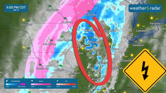
Home
Weather New York
WeatherRadar
RainRadar
TemperatureRadar
WindRadar
LightningRadar
Weather News
Editor's Pick
Discover the app
Weather widget
Contact us
Apps
Career
    Home / Weather News /

    Active Central Plains: rain snow, winds

09:00 AM
March 19, 2025

Breakfast brief
Active Central Plains: rain, snow, winds

On Wednesday, a storm system exits the Rockies, bringing strong winds over the Central Plains. In the evening, heavy rain and snow will reach the Great Lakes. The Breakfast Brief is published daily, Monday through Friday, at 5:00 a.m. Eastern time.

The same system that impacted the Rockies on Tuesday will affect the central Plains on Wednesday morning and move over the southern portion of the Great Lakes by the evening. Chicago through western Indiana has a chance for isolated severe storms that could produce damaging wind gusts and hail, mainly between the late afternoon and evening. Tornadoes are also possible in this area in the same time frame.

Severe storms could develop south of the Great Lakes on Wednesday afternoon.

A cold front will sweep through the South from the center of this low-pressure system. Houston could experience a few scattered showers on Wednesday morning as the front pushes through, and the line could become better defined as it moves east. By the afternoon, it will be pushing, from west to east, through Louisiana, Mississippi, and Alabama. There is a chance for some isolated storms in the afternoon.

As seen in our WindRadar, the winds will be extremely strong across the Ozarks after the cold front passes through and around the southern and western periphery of the low-pressure system. Gusts from Oklahoma through St. Louis and Des Moines could reach at least 50 mph. These winds can carry dust, which can obstruct visibility for some. With very dry air and strong gusts, there will be elevated fire risk across much of Texas and critically high conditions from the Mexican border to Midland.

Another storm for the West

Clouds will build during the day from west to east especially along the northern half the West Coast. The heaviest rain will move in during the late afternoon and continue to move inland, but still affect the coast through the evening. Heavy snow will arrive to the interior mountains where the Northern Sierra can expect 6 to 8 inches of snow, which can produce travel delays and slick roads.

This system will be moving rapidly west and another system will impact the Pacific Northwest, from Oregon through Washington on Thursday, where torrential rains will fall and there is a growing chance for flash floods to end the week.

Series of systems to impact the West Coast to end the workweek.

The news we are covering

  • Critical fire weather for Texas
  • Severe weather chance for Great Lakes and south
  • Another system to impact the West Coast.

Things you may have missed

Mississippi tornado damage clean-upread more

App News

Discover Our App! Hello! We have many new users for our app. Thank you for downloading us and keeping us close. Here, you will be able to find all the important features and explanations of the great tools our app offers, interesting weather features, and safety weather tips!

Irene Sans
More on the topic
Heat is affecting agriculture globally. WMO report. . . Sunday, April 26, 2026
A young woman is kneeling in a cornfield, tending to her plants
Sunday, April 26, 2026

WMO report

Heat is affecting agriculture globally
All about nocturnal severe weather. Risks & preparedness. . . Saturday, April 18, 2026
Saturday, April 18, 2026

Risks & preparedness

All about nocturnal severe weather
El Niño is gaining momentum. Temperature records?. . . Thursday, May 7, 2026
The image shows the central Pacific in a computer model. A striking feature is the ocean coloured red, which indicates very warm seawater.
Thursday, May 7, 2026

Temperature records?

El Niño is gaining momentum
All weather news
This might also interest you
Watch a Mesoscale Convective System. On the WeatherRadar. . . Monday, June 1, 2026
Monday, June 1, 2026

On the WeatherRadar

Watch a Mesoscale Convective System
Summer returns to East. Turn hot by Friday. . . Tuesday, June 2, 2026
Highs this week
Tuesday, June 2, 2026

Turn hot by Friday

Summer returns to East
Storms for the Plains, Mid-South. Damaging wind & hail. . . Monday, June 1, 2026
Strong storms target two regions of the U.S. today- the Plains and the Mid-South. Damaging winds and hail are the main threats.
Monday, June 1, 2026

Damaging wind & hail

Storms for the Plains, Mid-South
All articles
Weather & Radar

Weather & Radar is also available on

Google Play StoreApp Store

Company

Contact us Privacy policy Legal info Accessibility statement

Services

Uploader

Socials

instagramfacebookthreadslinkList