Home
Weather New York
WeatherRadar
RainRadar
TemperatureRadar
WindRadar
LightningRadar
Weather News
Editor's Pick
Discover the app
Weather widget
Contact us
Apps
Career
    Home / Editor's Pick /

    Active, fast-moving weather continues

10:00 AM
November 12, 2024

Breakfast Brief
Active, fast-moving weather continues

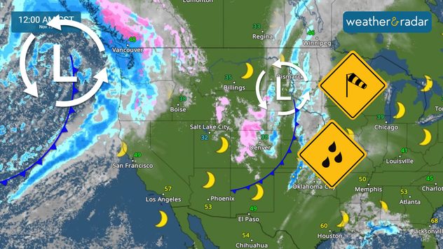
While one front exits east, another one arrives on Tuesday on the West Coast. The active weather continues for the Rockies; let's dive into the details. The Breakfast Brief is published every Monday through Friday at 5 a.m. ET

The West Coast's weather is trying to improve briefly, but another front will arrive late Tuesday, which promises to bring heavy rounds of rains for the lower elevations, mountain snow, and strong gusts. This storm will be followed by a cooler air mass that will take over much of the Pacific Northwest, northern California and the Rockies with another push of even cooler air to close the workweek. An atmospheric river makes its way, and it is expected to affect parts of the West this week, increasing torrential showers and snow around the middle of the week.

Our TemperatureRadar shows temperatures in the Central Plains through Texas will be above normal ahead of the cold front that will bring snow across the Rockies. The winds will be from the South and strong, gusting at times between 30 and 40 mph. Luckily, humidity levels will be present, so there is no fire risk.

The cold front that brought rains for the East on Veteran's Day exits, and while a few showers are still possible along the Southeast as the front fizzles out, the drier air will start to make its way south. South Florida can expect the first shot of drier air to arrive late Wednesday, which will reinforced later this week by another front, which will be stronger and likely dropping the lows across Miami and nearby cities to the mid to upper 60s by the weekend.

Tropical update:

An area over the western Caribbean could see tropical development late this week. Whatever develops here will be slow to develop, so we must continue to monitor it. Remember that without a well-defined center of circulation, it is impossible to know where a system might (or might not) go.

Weather history...

On November 12, 1970: The deadliest tropical cyclone ever recorded, and one of the deadliest natural disasters in modern times occurred on this day in East Pakistan, now Bangladesh. The Bhola Cyclone first formed over the Bay of Bengal on November 8 and traveled north. This cyclone reached peak intensity, Category 3, on the 11, and made landfall on the coast of East Pakistan the following afternoon. The Bhola Cyclone killed an estimated 500,000 people and caused nearly $90 million in damage.

News we are covering today:

  • Pac storm heads inland
  • Windy Central California
  • Major cooldown by the end of the week
  • The tropics are still prolific

Did you miss these?

Why? It's thundersnow seasonread more
Dry vegetation, low humidity and windsread more

App news & updates:

Our WeatherRadar goes with you wherever you go in the world. You can track storms and showers and see how a storm system moves up to 4 days in advance. This is all free and in your hands, always accessible. Exploring app featuresThe WeatherRadar our most popular tool

Irene Sans
More on the topic
Record-breaking heatwave in Europe. Hotter than most of U.S.. . . Thursday, June 25, 2026
Thursday, June 25, 2026

Hotter than most of U.S.

Record-breaking heatwave in Europe
Super Typhoon Bavi threatens Taiwan. 155 mph winds. . Weather Videos. Wednesday, July 8, 2026
The image shows an intense tropical cyclone over the western Pacific, east of Taiwan and the Philippines. The centre of the system is depicted as a light purple and white vortex with a clearly visible eye, surrounded by a ring of red and orange areas indicating the strongest wind speeds. A white arrow marks the typhoon’s predicted track towards the north-west, in the direction of Taiwan. To the west of the storm lie the Philippines, with the cities of Manila and Cebu; to the north of these lies Taiwan, with Taipei. Further west, the Chinese coast, including Hong Kong, and parts of Vietnam can be seen. The coloured wind map shows predominantly green areas outside the storm’s core, indicating significantly weaker winds. White streamlines illustrate the typhoon’s anti-clockwise circulation in the Northern Hemisphere. The highest wind speeds are concentrated around the eye of the cyclone.
Weather VideosWednesday, July 8, 2026

155 mph winds

Super Typhoon Bavi threatens Taiwan
Rip currents & safety tips. As more head to the coast. . . Saturday, July 25, 2026
rip current
Saturday, July 25, 2026

As more head to the coast

Rip currents & safety tips
All weather news
This might also interest you
How does a hurricane form?. Hurricane preparedness. . . Sunday, July 19, 2026
hurricane maria
Sunday, July 19, 2026

Hurricane preparedness

How does a hurricane form?
Dry vegetation, low humidity and winds. The perfect fire recipe. . . Sunday, July 26, 2026
Sunday, July 26, 2026

The perfect fire recipe

Dry vegetation, low humidity and winds
Up to four feet of storm surge. Gulf Coast soaker. . . Tuesday, July 21, 2026
Tropical storm alerts are active in the app as Bertha continues to churn in the northern Gulf.
Tuesday, July 21, 2026

Gulf Coast soaker

Up to four feet of storm surge
All articles
Weather & Radar

Weather & Radar is also available on

Google Play StoreApp Store

Company

Contact us Privacy policy Legal info Accessibility statement

Services

Uploader

Socials

instagramfacebookthreadslinkList