Home
Weather New York
WeatherRadar
RainRadar
TemperatureRadar
WindRadar
LightningRadar
Weather News
Editor's Pick
Discover the app
Weather widget
Contact us
Apps
Career
    Home / Weather News /

    Active Spring Tides: Flooding, Road Closures

02:46 PM
September 29, 2026

Happening along coasts
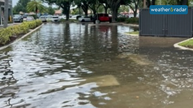
Spring Tides: Flooding, Road Closures

The colloquial term is "king tides" or "royal tides." But the scientific term is "perigee tide." Ultimately, it’s the same thing: high tides that cause coastal flooding.

The moon will be in its full phase during the last few weeks of September. During this time, it will also be at its closest point to Earth in its orbit—perigee—which occurs on October 1. During this period, low tides are expected to be lower than normal and high tides higher than normal, causing coastal problems.

Privacy policy

What are they? Where?

They are caused by the combined gravitational forces of the Sun and the Moon, which pull on the Earth’s oceans, creating the highest tides of the year. Spring tides typically occur along the entire East Coast. They are not particularly noticeable along much of the Gulf Coast due to the bathymetry—or the slope of the seafloor—which features a shallow continental shelf.

On average, high tide is about 2 to 3 feet along much of Florida’s east coast; in some areas, it can regularly be higher. With spring tides, up to one foot can be added to that height. These higher-than-normal tides could cause minor flooding along the coast and coastal erosion.

In cities like Miami, even when it doesn't rain, spring tides cause flooding on busy roads, such as in the city center or downtown. This water flows out through the sewer system and is often mixed with sewage, debris, and pollutants—and since it is saltwater—it can damage car bodies and, in some cases, pose a danger to people walking through it.

Higher-than-normal tides are affecting not only South Florida but also the entire U.S. East Coast and the Pacific Coast. Check the high tide time on our app if you're within 5 miles of the coast.

Irene Sans
More on the topic
What are weather fronts?. Weather explained. . . Sunday, August 23, 2026
Image of a temperature radar showing a clear distinction between a warm and cold air mass separated by a cold front.
Sunday, August 23, 2026

Weather explained

What are weather fronts?
Hurricane Polo remains dangerous. Active Pacific. . . Thursday, September 24, 2026
Thursday, September 24, 2026

Active Pacific

Hurricane Polo remains dangerous
How does fog form?. Multiple ways. . . Saturday, September 12, 2026
Saturday, September 12, 2026

Multiple ways

How does fog form?
All weather news
This might also interest you
30-degree drop on heels of equinox. Mid-Atlantic & Southeast. . . Monday, September 21, 2026
Monday, September 21, 2026

Mid-Atlantic & Southeast

30-degree drop on heels of equinox
Why are some sunsets so beautiful?. And why are some duds?. . . Sunday, September 20, 2026
Credit Mark Maxwell - St Joseph, Mich.
Sunday, September 20, 2026

And why are some duds?

Why are some sunsets so beautiful?
High winds whip East Coast. Nor'easter spins offshore. . . Friday, September 25, 2026
Friday, September 25, 2026

Nor'easter spins offshore

High winds whip East Coast
All articles
Weather & Radar

Weather & Radar is also available on

Google Play StoreApp Store

Company

Contact us Privacy policy Legal info Accessibility statement

Services

Uploader

Socials

instagramfacebookthreadslinkList