Home
Weather New York
WeatherRadar
RainRadar
TemperatureRadar
WindRadar
LightningRadar
Weather News
Editor's Pick
Discover the app
Weather widget
Contact us
Apps
Career
    Home / Weather News /

    Actualización tropical: Franklin rumbo norte a Rep. Dominicana

07:24 PM
August 22, 2023

Actualización tropical
Franklin rumbo norte a Rep. Dominicana

Mientras seguimos observando cómo Harold avanza tierra adentro sobre el sur de Texas y el noreste de México, ¡la cuenca del Atlántico continúa muy energética! El próximo sistema que tocará tierra será Franklin, con destino a República Dominicana a primera hora del miércoles. Veamos.

Franklin es una gran fabrica de lluvia
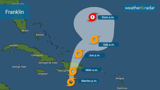
Cono de incertidumbre de Franklin emitido el martes por la mañana.

Franklin ha girado hacia el norte y se encuentra a unas 200 millas por hora al sur-suroeste de Santo Domingo, República Dominicana. Se pronostica que Franklin se intensificará un poco durante el resto del día del martes, probablemente alcanzando las 60 mph. Ahora que el sistema ha girado hacia el norte, comenzará a ganar velocidad a medida que se acerque a un punto probable de tocar tierra en Barahona, República Dominicana. Son posibles entre 2 y 4 pulgadas de lluvia, pero algunas áreas pueden recibir hasta 6 en Puerto Rico. Mientras que, en la República Dominicana y Haití, se pueden acumular hasta 15 pulgadas de lluvia y, en general, son posibles entre 5 y 10 pulgadas. Es posible que se produzcan deslizamientos de tierra.

Los vientos serán fuertes a lo largo de la costa sur de la República Dominicana y Haití, pero las ráfagas más fuertes llegarán al área este donde el centro toque tierra. El sistema viajará sobre las montañas más altas del Caribe el miércoles en la República Dominicana y emergerá sobre el Atlántico y traerá vientos con fuerza de tormenta tropical a las Islas Turcas y Caicos.

¡Gert es historia!

Tormenta Tropical Gert se convierte en un ciclón post-tropical y se espera que se mantenga débil ya que permanece estacionario al noreste del Caribe.

Lo que antes era Emily, ahora una onda tropical

Emily podría revivir a finales de esta semana, pero afortunadamente sobre el Atlántico subtropical y no representa una amenaza para tierra.

Onda tropical del Lejano Oriente

Tampoco parece que este sea un problema para tierra. Siguiendo los pasos de Emily permanecerá sobre el Atlántico Central.

**Pueden encontrar esta misma información en inglés (también escrito por nuestros meteorólogos) si su teléfono está en este idioma usando nuestra app.**

Irene Sans
More on the topic
Super Typhoon Bavi threatens Taiwan. 155 mph winds. . Weather Videos. Wednesday, July 8, 2026
The image shows an intense tropical cyclone over the western Pacific, east of Taiwan and the Philippines. The centre of the system is depicted as a light purple and white vortex with a clearly visible eye, surrounded by a ring of red and orange areas indicating the strongest wind speeds. A white arrow marks the typhoon’s predicted track towards the north-west, in the direction of Taiwan. To the west of the storm lie the Philippines, with the cities of Manila and Cebu; to the north of these lies Taiwan, with Taipei. Further west, the Chinese coast, including Hong Kong, and parts of Vietnam can be seen. The coloured wind map shows predominantly green areas outside the storm’s core, indicating significantly weaker winds. White streamlines illustrate the typhoon’s anti-clockwise circulation in the Northern Hemisphere. The highest wind speeds are concentrated around the eye of the cyclone.
Weather VideosWednesday, July 8, 2026

155 mph winds

Super Typhoon Bavi threatens Taiwan
Europe: Warmest June on record. Warm waters too. . . Friday, July 10, 2026
The record-breaking heatwave in June has made climate history in Western Europe.
Friday, July 10, 2026

Warm waters too

Europe: Warmest June on record
How does fog form?. Multiple ways. . . Saturday, July 11, 2026
Saturday, July 11, 2026

Multiple ways

How does fog form?
All weather news
This might also interest you
Temperatures rise 20 degrees at 2 am?. What is a heat burst?. . . Sunday, August 16, 2026
Heat burst in Nebraska
Sunday, August 16, 2026

What is a heat burst?

Temperatures rise 20 degrees at 2 am?
Hurricane Lala passes south of the Big Island. Flooding, wind in Hawaii. . . Sunday, August 16, 2026
Lala will continue to downgrade and pass south of the rest of the Hawaiian islands.
Sunday, August 16, 2026

Flooding, wind in Hawaii

Hurricane Lala passes south of the Big Island
6 riskiest places to live: hurricane edition. Do you live there?. . . Sunday, August 16, 2026
Hurricane Irma covers the entiret of Florida with Hurricane Maria coming up behind it.
Sunday, August 16, 2026

Do you live there?

6 riskiest places to live: hurricane edition
All articles
Weather & Radar

Weather & Radar is also available on

Google Play StoreApp Store

Company

Contact us Privacy policy Legal info Accessibility statement

Services

Uploader

Socials

instagramfacebookthreadslinkList