Home
Weather New York
WeatherRadar
RainRadar
TemperatureRadar
WindRadar
LightningRadar
Weather News
Editor's Pick
Discover the app
Weather widget
Contact us
Apps
Career
    Home / Weather News /

    All threats expected - Weekend storms target Plains, Northeast

04:22 PM
June 6, 2026

All threats expected
Weekend storms target Plains, Northeast

Saturday's outdoor plans may need to be moved indoors for some, as severe storms bring damaging gusts, large hail and even isolated tornadoes.

Midwest & Northeast

High pressure has dominated the forecast for the first week of June, and a new storm system will interrupt the quiet pattern on Saturday. At least isolated severe storms are possible from Iowa to Maine, but scattered activity is expected from the Upper Ohio Valley to western Massachusetts.

Isolated flash flooding cannot be ruled out.

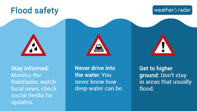
Flood safety tips: Stay informed, never drive into the water and get to higher ground
Flood safety tips: Stay informed, never drive into the water, and get to higher ground

Northern High Plains

Another storm system keeps the northern High Plains residents on their toes on Saturday night after a week full of severe weather forecasts. Damaging gusts and large hail are possible for places like Glasgow, Mont., and Williston, N.D. By Sunday, the storm threat only shifts slightly east, with a focus on North Dakota.

Have at least three ways to receive a weather warning and make sure your app alerts are switched on.

Share your weekend storm views with usread more
Becca Parker
More on the topic
Super Typhoon Bavi threatens Taiwan. 155 mph winds. . Weather Videos. Wednesday, July 8, 2026
The image shows an intense tropical cyclone over the western Pacific, east of Taiwan and the Philippines. The centre of the system is depicted as a light purple and white vortex with a clearly visible eye, surrounded by a ring of red and orange areas indicating the strongest wind speeds. A white arrow marks the typhoon’s predicted track towards the north-west, in the direction of Taiwan. To the west of the storm lie the Philippines, with the cities of Manila and Cebu; to the north of these lies Taiwan, with Taipei. Further west, the Chinese coast, including Hong Kong, and parts of Vietnam can be seen. The coloured wind map shows predominantly green areas outside the storm’s core, indicating significantly weaker winds. White streamlines illustrate the typhoon’s anti-clockwise circulation in the Northern Hemisphere. The highest wind speeds are concentrated around the eye of the cyclone.
Weather VideosWednesday, July 8, 2026

155 mph winds

Super Typhoon Bavi threatens Taiwan
Waterspouts possible, what are they?. They can be dangerous. . . Saturday, July 11, 2026
Waterspouts weatherradar.
Saturday, July 11, 2026

They can be dangerous

Waterspouts possible, what are they?
High pressure & extreme heat. Why & how does it work?. . . Sunday, July 12, 2026
Sunday, July 12, 2026

Why & how does it work?

High pressure & extreme heat
All weather news
This might also interest you
Turning hot this weekend. Brutal temps across West. . . Friday, July 10, 2026
Saturday & Sunday's highs
Friday, July 10, 2026

Brutal temps across West

Turning hot this weekend
Saharan dust to reach Florida. Dry period expected. . . Tuesday, July 7, 2026
Saharan dust seen on the satllite image (right) moving westward toward Florida. Air quality impacts are expected.
Tuesday, July 7, 2026

Dry period expected

Saharan dust to reach Florida
Slow-moving storms and heavy rain. What to look for. . . Monday, July 6, 2026
Monday, July 6, 2026

What to look for

Slow-moving storms and heavy rain
All articles
Weather & Radar

Weather & Radar is also available on

Google Play StoreApp Store

Company

Contact us Privacy policy Legal info Accessibility statement

Services

Uploader

Socials

instagramfacebookthreadslinkList