Home
Weather New York
WeatherRadar
RainRadar
TemperatureRadar
WindRadar
LightningRadar
Weather News
Editor's Pick
Discover the app
Weather widget
Contact us
Apps
Career
    Home / Editor's Pick /

    All threats present - Ohio & Tennessee valleys in the bullseye

02:00 PM
May 26, 2024

All threats present
Ohio & Tennessee valleys in bullseye

After a deadly night across Texas and Oklahoma, with 24 tornado reports happening across Texas, Oklahoma, northern Arkansas, and southern Missouri, severe storms moved eastward on Sunday, putting around 20 million people at risk of numerous storms and several tornadoes.

Sunday morning is an active one across southern Illinois and western Kentucky where there is a tornado watch in effect at least until 10 a.m. CT. Severe storms are moving in from the west and we forecast them to gain more terrain and strength later this afternoon once the low-pressure system and fronts inch closer and over the Great Plains and Ohio River Valley.

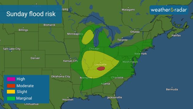
Sunday flood risk. Up to 5 inches in isolated areas are possible. Watch out for river, creek overflow.

Increasing flood risk

The low-pressure system is a slow move as it will merge with a larger system passing over the Great Lakes area late on Monday. Therefore, the rain will be heavy and constant for at least 24 hours over Ohio, Indiana, Kentucky, southern Illinois, and Tennessee, putting over 8.5 million people at risk of floods. Some areas could receive over 3 inches of rain, with some isolated spots receiving over 5 inches. Excessive runoff could flood rivers, creeks, and streams. Please make sure to follow the authorities’ orders if you are or live near a river.

Severe risk

The severe storm threat continues Sunday, with much of the Ohio Valley under an enhanced risk, level 3 of 5 on the severity scale. After the day’s heating and with plenty of moisture in the atmosphere, severe storms will fire up in the afternoon into the evening. Be aware that all threats are present today; damaging winds of at least 75 mph, large hail, and a few strong tornadoes.

On Monday, the system slowly migrates eastward. Across the Mid-Atlantic, the storms will arrive late in the afternoon into the night. The main threats will be damaging winds and hail. There is also the risk of severe storms across the Gulf States as a dragging front combined with deep moisture and plenty of heat will increase the storm potential which mostly includes the potential for very strong winds.

We will bring you prompt updates, and we have our weather reporter Jonathan Petramala on location in the enhanced risk and will bring you updates.

Irene Sans
More on the topic
Super Typhoon Bavi threatens Taiwan. 155 mph winds. . Weather Videos. Wednesday, July 8, 2026
The image shows an intense tropical cyclone over the western Pacific, east of Taiwan and the Philippines. The centre of the system is depicted as a light purple and white vortex with a clearly visible eye, surrounded by a ring of red and orange areas indicating the strongest wind speeds. A white arrow marks the typhoon’s predicted track towards the north-west, in the direction of Taiwan. To the west of the storm lie the Philippines, with the cities of Manila and Cebu; to the north of these lies Taiwan, with Taipei. Further west, the Chinese coast, including Hong Kong, and parts of Vietnam can be seen. The coloured wind map shows predominantly green areas outside the storm’s core, indicating significantly weaker winds. White streamlines illustrate the typhoon’s anti-clockwise circulation in the Northern Hemisphere. The highest wind speeds are concentrated around the eye of the cyclone.
Weather VideosWednesday, July 8, 2026

155 mph winds

Super Typhoon Bavi threatens Taiwan
Longest day of the year is here. Summer solstice. . . Sunday, June 21, 2026
Sunday, June 21, 2026

Summer solstice

Longest day of the year is here
Waterspouts possible, what are they?. They can be dangerous. . . Saturday, July 11, 2026
Waterspouts weatherradar.
Saturday, July 11, 2026

They can be dangerous

Waterspouts possible, what are they?
All weather news
This might also interest you
When severe storms strike.... You can be ready. . . Sunday, July 26, 2026
Sunday, July 26, 2026

You can be ready

When severe storms strike...
Heat indices soaring. High humidity. . . Saturday, July 25, 2026
Saturday, July 25, 2026

High humidity

Heat indices soaring
Dry vegetation, low humidity and winds. The perfect fire recipe. . . Sunday, July 26, 2026
Sunday, July 26, 2026

The perfect fire recipe

Dry vegetation, low humidity and winds
All articles
Weather & Radar

Weather & Radar is also available on

Google Play StoreApp Store

Company

Contact us Privacy policy Legal info Accessibility statement

Services

Uploader

Socials

instagramfacebookthreadslinkList