Home
Weather New York
WeatherRadar
RainRadar
TemperatureRadar
WindRadar
LightningRadar
Weather News
Editor's Pick
Discover the app
Weather widget
Contact us
Apps
Career
    Home / Editor's Pick /

    Another gigantic storm: Severe weather followed by polar temps

03:24 PM
January 12, 2024

Another gigantic storm
Severe weather followed by polar temps

The second gigantic winter storm of the week continues its course to the east of the country, bringing large and intense impacts of all kinds for Friday and Saturday.

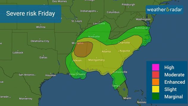
After an early morning with some severe storms, mostly over Arkansas on Friday, that produced more than a dozen damaging winds reports and an equal number of hail reports, the low-pressure system will continue to increase the risk of storms this morning over the Southeast. A severe storm watch is in place for the northern half of Mississippi and this may expand to the northern half of Alabama once this system continues to move east.

Severe weather risk for Friday, mainly Friday morning for Mississippi & Alabama.

The arrival time of the storms over the Southeast is expected to be in the afternoon, which has limited the amount of warmth that this region will achieve, and this has decreased the risk of severity for Georgia, the Carolinas, and northern Florida, now at a level 2 out of 5 on the scale. Some severe storms may develop tornadoes, but the greatest risk will be from strong winds over 75 mph. Please be vigilant and limit your time outdoors if you are located in the area highlighted in yellow.

The cold front associated with this system loses strength as it moves over Florida, so the risk to Central Florida decreases even further, to a level 1 of 5. Central Florida could see isolated strong to severe storms by Friday night, with the biggest threat still being the winds.

A little of the same—a lot of rain for the Northeast

For the northeast of the country, Tuesday’s weather pattern repeats. Some snowfall will be affecting portions of the interior of the Northeast. Rain will be affecting much of the central Atlantic and the tri-state area during Friday afternoon and evening.

With this storm, I am also concerned about the strong storms that will be passing through the tri-state area during the early morning hours and Saturday morning. Some of these storms will bring heavy rains and could also bring severe weather such as tornadoes, destructive winds, and hail, especially over parts of New England. Residents of southern New England, including Boston, should be very attentive to what is happening with the storms. See the WeatherRadar focused on this region.

Strong winds

The strong winds will give more to talk about to end this week as well. Gusts that may exceed 75 mph will be likely across the Great Lakes region. Sustained wind will also be blowing strongly along the east coast of the United States. Also, the Tennessee Valley and Mississippi, all the way to Florida will still have strong winds on Saturday but with the direction changing the component will be mostly from the north, which will pull an extremely cold air mass across the region.

Frozen Plains!

A polar air mass moves over the Rockies and Plains. The cold will be intense and very dangerous. In the Plains the wind is added, making the situation even worse. Temperatures up to 40 degrees below normal for Sunday morning for portions of the Northern Plains and 15 degrees below normal for North Texas. In Dallas, residents will wake to temperatures around 16 degrees on Sunday.

We will continue to provide you with information about the evolution of this storm here in our app and through social networks.

**This same information can be seen in Spanish, written by our bilingual meteorologists if you set our app to Spanish inside the settings option on the top right. Tell your family and friends who only speak Spanish so that they can also be informed and stay safe, please.**

Irene Sans
More on the topic
How does fog form?. Multiple ways. . . Saturday, July 11, 2026
Saturday, July 11, 2026

Multiple ways

How does fog form?
Super Typhoon Bavi threatens Taiwan. 155 mph winds. . Weather Videos. Wednesday, July 8, 2026
The image shows an intense tropical cyclone over the western Pacific, east of Taiwan and the Philippines. The centre of the system is depicted as a light purple and white vortex with a clearly visible eye, surrounded by a ring of red and orange areas indicating the strongest wind speeds. A white arrow marks the typhoon’s predicted track towards the north-west, in the direction of Taiwan. To the west of the storm lie the Philippines, with the cities of Manila and Cebu; to the north of these lies Taiwan, with Taipei. Further west, the Chinese coast, including Hong Kong, and parts of Vietnam can be seen. The coloured wind map shows predominantly green areas outside the storm’s core, indicating significantly weaker winds. White streamlines illustrate the typhoon’s anti-clockwise circulation in the Northern Hemisphere. The highest wind speeds are concentrated around the eye of the cyclone.
Weather VideosWednesday, July 8, 2026

155 mph winds

Super Typhoon Bavi threatens Taiwan
Meteorological summer is here!. Bye, spring!. . . Monday, June 1, 2026
Monday, June 1, 2026

Bye, spring!

Meteorological summer is here!
All weather news
This might also interest you
Up to four feet of storm surge. Gulf Coast soaker. . . Tuesday, July 21, 2026
Tropical storm alerts are active in the app as Bertha continues to churn in the northern Gulf.
Tuesday, July 21, 2026

Gulf Coast soaker

Up to four feet of storm surge
Heat indices soaring. High humidity. . . Saturday, July 25, 2026
Saturday, July 25, 2026

High humidity

Heat indices soaring
Intense rain for the Northeast. Flooding possible. . . Tuesday, July 28, 2026
Tuesday, July 28, 2026

Flooding possible

Intense rain for the Northeast
All articles
Weather & Radar

Weather & Radar is also available on

Google Play StoreApp Store

Company

Contact us Privacy policy Legal info Accessibility statement

Services

Uploader

Socials

instagramfacebookthreadslinkList