Home
Weather New York
WeatherRadar
RainRadar
TemperatureRadar
WindRadar
LightningRadar
Weather News
Editor's Pick
Discover the app
Weather widget
Contact us
Apps
Career
    Home / Weather News /

    Another powerful storm on the way next week, what to watch for

06:30 PM
January 4, 2024

Next week
Another powerful storm on the way

A powerful weekend storm will bring snow, ice, and storms to much of the eastern half of the U.S., and another storm system is set to move over many of the same areas next week.

An active storm pattern is setting up across the U.S., and while we do have our eyes on a weekend system, another powerful storm will be right on its heels.

Weekend stormread more

The WeatherRadar shows a powerful trough digging into the West Coast this weekend. Once the trough moves east of the Rockies, a surface low will develop over the southern Plains on Monday. This system will have deep Gulf moisture to tap into as it impacts the eastern half of the U.S., something that will allow for severe thunderstorms.

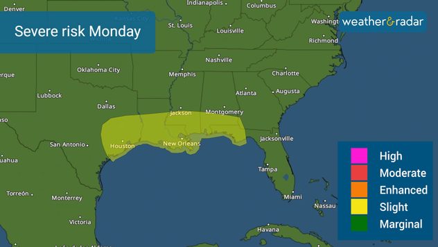
Severe risk Monday

A slight risk, a level two out of five for severe storms, is already in place Monday stretching along the Gulf Coast from Houston to Pensacola, Fla. Cities such as New Orleans and Mobile, Ala., may see strong storms Monday into Monday night. The severe weather risk extends across southern Georgia into central Florida Tuesday, where a slight risk is in place from Savannah, Ga. to Orlando and Tampa, Fla.

Heavy rain will also lead to the potential for flash flooding across much of the South and Southeast. Now is the time to turn on those Weather & Radar app alerts.

On the cold side of this system, heavy snow, ice, and blizzard conditions are possible as the low tracks from the central Plains into the Midwest and Northeast Monday through Wednesday. With this system still a few days out, changes to the forecast are likely. Weather & Radar's meteorologists will keep you up-to-date with the latest on this active pattern.

More on the topic
All about nocturnal severe weather. Risks & preparedness. . . Saturday, August 22, 2026
Saturday, August 22, 2026

Risks & preparedness

All about nocturnal severe weather
Record ocean heat halting hurricanes. Strong El Niño influence. . . Sunday, September 13, 2026
A weather map shows a calm Atlantic Ocean with no hurricanes, alongside a picture of the sea.
Sunday, September 13, 2026

Strong El Niño influence

Record ocean heat halting hurricanes
Waterspouts possible, what are they?. They can be dangerous. . . Sunday, August 9, 2026
Waterspouts weatherradar.
Sunday, August 9, 2026

They can be dangerous

Waterspouts possible, what are they?
All weather news
This might also interest you
Southwest turns hot, again!. New round of extreme heat. . . Wednesday, September 9, 2026
Hot weather across the Southwest.
Wednesday, September 9, 2026

New round of extreme heat

Southwest turns hot, again!
More than 20 inches of rain from Edouard. Possible drought help?. . . Thursday, September 3, 2026
Thursday, September 3, 2026

Possible drought help?

More than 20 inches of rain from Edouard
Peak season but no activity. Atlantic Basin. . . Thursday, September 10, 2026
A quiet Atlantic at the peak of Atlantic Hurricane Season.
Thursday, September 10, 2026

Atlantic Basin

Peak season but no activity
All articles
Weather & Radar

Weather & Radar is also available on

Google Play StoreApp Store

Company

Contact us Privacy policy Legal info Accessibility statement

Services

Uploader

Socials

instagramfacebookthreadslinkList