Home
Weather New York
WeatherRadar
RainRadar
TemperatureRadar
WindRadar
LightningRadar
Weather News
Editor's Pick
Discover the app
Weather widget
Contact us
Apps
Career
    Home / Weather News /

    Arctic blast reaches Sunshine State

05:19 PM
February 2, 2026

Frigid Sunshine State
Record cold chills Florida

Florida's cold streak continues

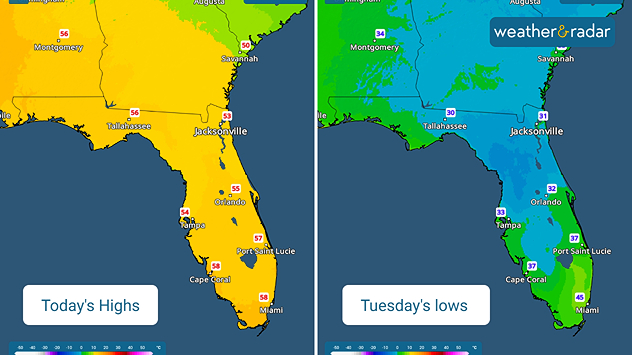
The arctic temperatures that have chilled much of the central and eastern U.S. over the past several weeks has settled deep across the South and into Florida.

Numerous daily low temperature records have been set over the past several days across Florida. In Melbourne, Fla., this morning's low of 24 degrees breaks the lowest ever temperature recorded at the location for the month of February. The previous record of 25 degrees was set yesterday, February 1st — the previous February record was 27 degrees set on February 26th, 1967. What a streak of cold weather!

Privacy policy

This latest arctic blast has reached its coldest valley as temperatures slowly rebound. However, the TemperatureRadar does show at least one more night of subfreezing temperatures across northern and central Florida tonight before highs finally return to the low 70s on Wednesday in Miami and Tampa.

Tampa

We
80
91
Th
78
90
Fr
77
90
Sa
78
88
Su
78
85
Mo
75
88
Tu
78
93
We
80
95
Th
80
93
Fr
80
93
Sa
80
94
Su
80
94
Mo
79
94
Tu
79
94
Max (°F)
Min (°F)
moreless

Don't get too excited, though. Another shot of arctic air arrives for the week's second half, bringing more near-freezing conditions to the Southeast.

James West
More on the topic
The best views of Wednesday's eclipse. Europe's sky show. . . Thursday, August 13, 2026
Solar eclipse: The sun obscured between wind turbines in Sardinia
Thursday, August 13, 2026

Europe's sky show

The best views of Wednesday's eclipse
How does fog form?. Multiple ways. . . Saturday, July 11, 2026
Saturday, July 11, 2026

Multiple ways

How does fog form?
Super Typhoon Bavi threatens Taiwan. 155 mph winds. . Weather Videos. Wednesday, July 8, 2026
The image shows an intense tropical cyclone over the western Pacific, east of Taiwan and the Philippines. The centre of the system is depicted as a light purple and white vortex with a clearly visible eye, surrounded by a ring of red and orange areas indicating the strongest wind speeds. A white arrow marks the typhoon’s predicted track towards the north-west, in the direction of Taiwan. To the west of the storm lie the Philippines, with the cities of Manila and Cebu; to the north of these lies Taiwan, with Taipei. Further west, the Chinese coast, including Hong Kong, and parts of Vietnam can be seen. The coloured wind map shows predominantly green areas outside the storm’s core, indicating significantly weaker winds. White streamlines illustrate the typhoon’s anti-clockwise circulation in the Northern Hemisphere. The highest wind speeds are concentrated around the eye of the cyclone.
Weather VideosWednesday, July 8, 2026

155 mph winds

Super Typhoon Bavi threatens Taiwan
All weather news
This might also interest you
Rainfall deficit tops a foot. Southeast Florida. . . Tuesday, August 18, 2026
All heat and no rain for Southeast Florida today.
Tuesday, August 18, 2026

Southeast Florida

Rainfall deficit tops a foot
Hurricane Lala passes south of the Big Island. Flooding, wind in Hawaii. . . Sunday, August 16, 2026
Lala will continue to downgrade and pass south of the rest of the Hawaiian islands.
Sunday, August 16, 2026

Flooding, wind in Hawaii

Hurricane Lala passes south of the Big Island
Understanding the feels like temperature. Advanced heat measurement. . . Saturday, August 15, 2026
feels like temperature
Saturday, August 15, 2026

Advanced heat measurement

Understanding the feels like temperature
All articles
Weather & Radar

Weather & Radar is also available on

Google Play StoreApp Store

Company

Contact us Privacy policy Legal info Accessibility statement

Services

Uploader

Socials

instagramfacebookthreadslinkList