Home
Weather New York
WeatherRadar
RainRadar
TemperatureRadar
WindRadar
LightningRadar
Weather News
Editor's Pick
Discover the app
Weather widget
Contact us
Apps
Career
    Home / Weather News /

    Atmospheric Rivers: What are they?

What are they?
Atmospheric Rivers

Atmospheric river season is upon us! What are these powerful systems?

Flooding rains and mountain snow are just a couple of the impacts an atmospheric river can bring. But, what is an atmospheric river?

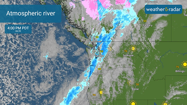
Atmospheric rivers are narrow bands of concentrated moisture in the atmosphere that bring large amounts of moisture from tropical regions to higher latitudes. When these air streams encounter land, they release precipitation, ranging from light rain to intense downpours, depending on the conditions. You can see the atmospheric river from this weekend on the WeatherRadar.

The West Coast typically sees atmospheric rivers during the winter months. Atmospheric rivers play a vital role for this region of the U.S. They replenish mountain snow levels and fill reservoirs. However, atmospheric rivers sometimes lead to extreme weather events. For example, when they bring heavy rain to areas with already saturated soil, the result can be flooding and landslides.

Mary Mays
This might also interest you
100 miles, 30-degree difference. Southern California. . . Thursday, July 9, 2026
Thursday, July 9, 2026

Southern California

100 miles, 30-degree difference
Super Typhoon Bavi threatens Taiwan. 155 mph winds. . Weather Videos. Wednesday, July 8, 2026
The image shows an intense tropical cyclone over the western Pacific, east of Taiwan and the Philippines. The centre of the system is depicted as a light purple and white vortex with a clearly visible eye, surrounded by a ring of red and orange areas indicating the strongest wind speeds. A white arrow marks the typhoon’s predicted track towards the north-west, in the direction of Taiwan. To the west of the storm lie the Philippines, with the cities of Manila and Cebu; to the north of these lies Taiwan, with Taipei. Further west, the Chinese coast, including Hong Kong, and parts of Vietnam can be seen. The coloured wind map shows predominantly green areas outside the storm’s core, indicating significantly weaker winds. White streamlines illustrate the typhoon’s anti-clockwise circulation in the Northern Hemisphere. The highest wind speeds are concentrated around the eye of the cyclone.
Weather VideosWednesday, July 8, 2026

155 mph winds

Super Typhoon Bavi threatens Taiwan
Tough sleeping temperatures too. Stifling hot night & day. . . Thursday, July 2, 2026
Friday's temperatures
Thursday, July 2, 2026

Stifling hot night & day

Tough sleeping temperatures too
All articles
Weather & Radar

Weather & Radar is also available on

Google Play StoreApp Store

Company

Contact us Privacy policy Legal info Accessibility statement

Services

Uploader

Socials

instagramfacebookthreadslinkList