Home
Weather New York
WeatherRadar
RainRadar
TemperatureRadar
WindRadar
LightningRadar
Weather News
Editor's Pick
Discover the app
Weather widget
Contact us
Apps
Career
    Home / Editor's Pick /

    Beryl arrives in Mexico - Expected to restrengthen before Texas

01:33 PM
July 5, 2024

Beryl arrives in Mexico
Expected to restrengthen before Texas

Beryl hit the Cayman Islands on Thursday and landed on the Yucatan Peninsula this Friday morning. We expect it to go out into the Gulf and make its final landfall in the U.S.

After passing through Jamaica and the Cayman Islands, Beryl was downgraded to a category 2 hurricane, but on Thursday night it again grew to a category 3 hurricane just before sharp wind shear again took it to category 2 just before touching Mexican soil, just northeast of Tulum.

The hurricane will continue to hit the Yucatan Peninsula this Friday and is expected to emerge over the Gulf of Mexico early Saturday. As it passes over the north of the Peninsula it will be battling friction which will degrade it to a tropical storm by the end of Friday.

U.S. impact?

Beryl will spend the entire weekend traveling northwest toward South Texas. As it travels through the warm Gulf of Mexico, conditions will become more suitable for it to strengthen again. It is forecast to reach southern Texas as a hurricane. The extreme northeast of Mexico will also be dealing with heavy rains and hurricane-force winds. However, the strongest and most direct impact is expected for the Rio Grande Valley to Corpus Christi.

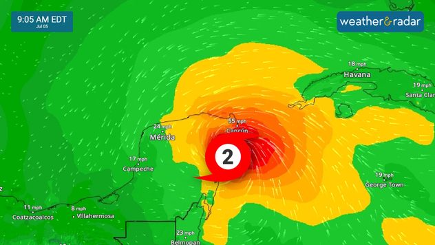
Beryl´s winds in Mexico.
Beryl on our WindRadar focused over the Yucatán Peninsula in Mexico.

Storm surge will also be quite significant. As I mentioned on Wednesday, Beryl will be growing in size and the rotation of the storm will be pushing large amounts of water to the Texas coast and possibly western Louisiana. Please take precautionary measures if you live on the coast and know that the impacts will reach further outside the cone of uncertainty, due to the size of the storm.

We are closely monitoring this storm, its trajectory, and its impacts. It is still possible that there will be some adjustments to the trajectory. We will bring you updates, make sure you have your alerts on.

Irene Sans
More on the topic
Hurricane Polo heads for Mexico. Severe weather risk. . . Monday, September 28, 2026
Hurricane Polo is set to make landfall in the Baja-California.
Monday, September 28, 2026

Severe weather risk

Hurricane Polo heads for Mexico
Hurricane Polo remains dangerous. Active Pacific. . . Thursday, September 24, 2026
Thursday, September 24, 2026

Active Pacific

Hurricane Polo remains dangerous
The average first frosts in the U.S.. Meteorological autumn. . . Sunday, October 4, 2026
First frosts can begin in September as autumn temps move in.
Sunday, October 4, 2026

Meteorological autumn

The average first frosts in the U.S.
All weather news
This might also interest you
Autumn foliage: weather's impact. Leaf-peeping season!. . . Sunday, October 4, 2026
Cool nights can help intensify autumn foliage color!
Sunday, October 4, 2026

Leaf-peeping season!

Autumn foliage: weather's impact
Spring Tides: Flooding, Road Closures. Happening along coasts. . . Tuesday, September 29, 2026
Tuesday, September 29, 2026

Happening along coasts

Spring Tides: Flooding, Road Closures
Hurricane drought in the Atlantic. 352 days and counting. . . Wednesday, September 30, 2026
The last hurricane to form in the Atlantic was Hurricane Melissa on October 13, 2025, 352 days ago. So what's responsible for this hurricane drought?
Wednesday, September 30, 2026

352 days and counting

Hurricane drought in the Atlantic
All articles
Weather & Radar

Weather & Radar is also available on

Google Play StoreApp Store

Company

Contact us Privacy policy Legal info Accessibility statement

Services

Uploader

Socials

instagramfacebookthreadslinkList