Home
Weather New York
WeatherRadar
RainRadar
TemperatureRadar
WindRadar
LightningRadar
Weather News
Editor's Pick
Discover the app
Weather widget
Contact us
Apps
Career
    Home / Editor's Pick /

    Big pattern change - Heavy rain coming to Florida?

10:30 PM
June 6, 2024

Big pattern change
Heavy rain coming to Florida?

Recommended external content from YouTube

We need your consent to show content from YouTube. You can withdraw your consent at any time.
I agree that content from YouTube will be displayed to me.
Privacy policy

For most of Florida, the rainy season has arrived, but for many, the rain, itself, hasn’t. This is about to change though.

Florida is to ramp up the rain activity, especially toward the beginning of next week. First, there will be a very weak cold front trying to travel over the start by the end of this week. It will not surprise you to know that this front will not make it all the way south. The fronts season is long gone, and this one will increase the warmth ahead of it, shifting the winds, allowing winds from the south-southwest on Friday which will bump the low and high temperatures to record levels or very close to it.

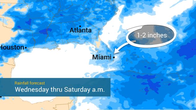
Rainfall through Saturday

By the weekend, the front will be losing its punch, but deep tropical moisture will be approaching South Florida from the southwest. We are about 6 days out from this event, so it is hard to pinpoint the exact locations for the highest amounts. It is safe to say that showers and storms will be profound across the southern portion of Florida between Monday and early Wednesday.

June's mess!

June tropical systems tend to form near the coast, either just over the eastern coast of the U.S. or in the Gulf of Mexico. They often form from the leftover energy left behind by fronts. Usually, June tropical systems are very messy, with most of their convection shifted to the east.

The big question remains, will this deep tropical moisture expand sufficiently to cover the rest of Florida? It will depend. There seem to be several tropical waves approaching Florida, also the GFS model is signaling some infant storms emerging from the Caribbean, intensifying and moving on to the Gulf of Mexico and staying just west of Florida. But of course, this is just one model, and there are many days between now and then.

What’s certain is that Florida is about to have a pattern change and residents need to be aware. Especially with the kids and vacations, your plans could be impacted by storms and downpours. Please check back often, we have our daily tropical updates issued every morning inside our breakfast briefing and if a storm is brewing you can look for a specific article with in-depth analysis.

Irene Sans
More on the topic
Longest day of the year is here. Summer solstice. . . Sunday, June 21, 2026
Sunday, June 21, 2026

Summer solstice

Longest day of the year is here
Europe: Warmest June on record. Warm waters too. . . Friday, July 10, 2026
The record-breaking heatwave in June has made climate history in Western Europe.
Friday, July 10, 2026

Warm waters too

Europe: Warmest June on record
Super Typhoon Bavi threatens Taiwan. 155 mph winds. . Weather Videos. Wednesday, July 8, 2026
The image shows an intense tropical cyclone over the western Pacific, east of Taiwan and the Philippines. The centre of the system is depicted as a light purple and white vortex with a clearly visible eye, surrounded by a ring of red and orange areas indicating the strongest wind speeds. A white arrow marks the typhoon’s predicted track towards the north-west, in the direction of Taiwan. To the west of the storm lie the Philippines, with the cities of Manila and Cebu; to the north of these lies Taiwan, with Taipei. Further west, the Chinese coast, including Hong Kong, and parts of Vietnam can be seen. The coloured wind map shows predominantly green areas outside the storm’s core, indicating significantly weaker winds. White streamlines illustrate the typhoon’s anti-clockwise circulation in the Northern Hemisphere. The highest wind speeds are concentrated around the eye of the cyclone.
Weather VideosWednesday, July 8, 2026

155 mph winds

Super Typhoon Bavi threatens Taiwan
All weather news
This might also interest you
Lopsided Bertha moves west. Who sees the impacts. . . Thursday, July 23, 2026
Thursday, July 23, 2026

Who sees the impacts

Lopsided Bertha moves west
Gulf system is becoming better organized. It moves slowly. . . Monday, July 20, 2026
Monday, July 20, 2026

It moves slowly

Gulf system is becoming better organized
Temps 15-degrees below average. Big cold front. . . Wednesday, July 22, 2026
Wednesday, July 22, 2026

Big cold front

Temps 15-degrees below average
All articles
Weather & Radar

Weather & Radar is also available on

Google Play StoreApp Store

Company

Contact us Privacy policy Legal info Accessibility statement

Services

Uploader

Socials

instagramfacebookthreadslinkList