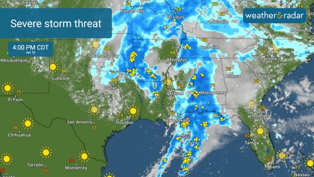
Home
Weather New York
WeatherRadar
RainRadar
TemperatureRadar
WindRadar
LightningRadar
Weather News
Editor's Pick
Discover the app
Weather widget
Contact us
Apps
Career
    Home / Weather News /

    Breakfast brief: Dangerous severe threat continues

09:00 AM
April 10, 2024

Breakfast brief
Dangerous severe threat continues

More severe weather is in the forecast across the South as an upper-level low clashes with warm moist air from the Gulf of Mexico. Rain and mountain snow will continue to impact the Pacific Northwest.

Coldest April temperature on record

The temperature at Eagles Nest, NM, plunged to 45 degrees below zero to establish an April record for the United States.

Today's weather outlook

The WeatherRadar will be active once again across the South as a multi-day severe weather threat continues. Today, the lower Mississippi Valley and Gulf Coast states have the greatest risk of severe storms. Tornadoes, some strong, widespread damaging winds, and large hail are threats that could happen anytime from morning through afternoon and continue into the evening and overnight hours.

Severe storms today

With a moderate risk, a level four out of five, of severe storms in place in southeastern Louisiana, southern Mississippi, and southwestern Alabama, it's important to stay weather aware. Flash flooding is also a significant concern stretching across the Southeast.

News we're covering today:

  • Severe storms and flash flooding threats across the South.
  • Tranquil for much of the U.S. (with the exception of the South).
  • Rain tracks toward the lower Great Lakes.

Did you miss these?

Tuesday's live blogread more
How to turn on weather alertsread more
Solar Eclipse Hubread more

App news & updates:

Weather & Radar wants to keep you up-to-date with the latest information, which is why we have live blogs when severe weather strikes. Want to know if our blog is live? Look for the live icon in the upper left-hand corner.

More on the topic
Tornado myths answered. World of Twisters. . . Saturday, April 18, 2026
EF-2 tornado pictured in Colorado
Saturday, April 18, 2026

World of Twisters

Tornado myths answered
El Niño is gaining momentum. Temperature records?. . . Thursday, May 7, 2026
The image shows the central Pacific in a computer model. A striking feature is the ocean coloured red, which indicates very warm seawater.
Thursday, May 7, 2026

Temperature records?

El Niño is gaining momentum
High pressure & extreme heat. Why & how does it work?. . . Sunday, April 19, 2026
Sunday, April 19, 2026

Why & how does it work?

High pressure & extreme heat
All weather news
This might also interest you
Arthur forms. Gulf Coast soaker. . . Wednesday, June 17, 2026
Arthur forms
Wednesday, June 17, 2026

Gulf Coast soaker

Arthur forms
Tropical system brings more flooding issues for Texas, Deep South. Over 10 inches possible. . . Tuesday, June 16, 2026
Tuesday, June 16, 2026

Over 10 inches possible

Tropical system brings more flooding issues for Texas, Deep South
Low pressure triggers stormy skies. Midwest. . . Tuesday, June 16, 2026
Tuesday, June 16, 2026

Midwest

Low pressure triggers stormy skies
All articles
Weather & Radar

Weather & Radar is also available on

Google Play StoreApp Store

Company

Contact us Privacy policy Legal info Accessibility statement

Services

Uploader

Socials

instagramfacebookthreadslinkList