Home
Weather New York
WeatherRadar
RainRadar
TemperatureRadar
WindRadar
LightningRadar
Weather News
Editor's Pick
Discover the app
Weather widget
Contact us
Apps
Career
    Home / Weather News /

    Breakfast brief: Severe storm threat continues

09:00 AM
April 16, 2024

Breakfast brief
Severe storm threat continues

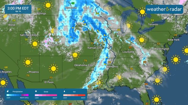
Another day of severe weather is on tap, with today's threat focusing on parts of the Midwest and Mississippi Valley. All types of severe weather are possible; please stay alert!

Coldest April temperature on record

The temperature at Eagles Nest, NM, plunged to 45 degrees below zero to establish an April record for the United States.

Today's weather outlook

Scattered severe thunderstorms are possible across parts of the Midwest and Mississippi Valley starting this morning and continuing into the afternoon and evening. The most concentrated threat of tornadoes and hail extends across southern Iowa into northern Missouri and west-central Illinois.

WeatherRadar April 16

You will also want to keep an eye on the TemperatureRadar across Texas and into the Southeast where temperatures remain above average. Cooler weather prevails in the Northwest, where mountain snow is set to fall in the Cascades.

News we're covering today:

  • Severe threat continues.
  • Above-average temperatures across the South.

Did you miss these?

Large smoke plume affects Miamiread more
Record-breaking heatread more

App news & updates:

Want to know when severe weather is nearing your area? Weather & Radar app alerts can help keep you safe.

How to turn on weather alertsread more
More on the topic
Heat wave setting records across Europe. London breaks May record. . . Tuesday, May 26, 2026
European heat wave
Tuesday, May 26, 2026

London breaks May record

Heat wave setting records across Europe
Super Typhoon Bavi threatens Taiwan. 155 mph winds. . Weather Videos. Wednesday, July 8, 2026
The image shows an intense tropical cyclone over the western Pacific, east of Taiwan and the Philippines. The centre of the system is depicted as a light purple and white vortex with a clearly visible eye, surrounded by a ring of red and orange areas indicating the strongest wind speeds. A white arrow marks the typhoon’s predicted track towards the north-west, in the direction of Taiwan. To the west of the storm lie the Philippines, with the cities of Manila and Cebu; to the north of these lies Taiwan, with Taipei. Further west, the Chinese coast, including Hong Kong, and parts of Vietnam can be seen. The coloured wind map shows predominantly green areas outside the storm’s core, indicating significantly weaker winds. White streamlines illustrate the typhoon’s anti-clockwise circulation in the Northern Hemisphere. The highest wind speeds are concentrated around the eye of the cyclone.
Weather VideosWednesday, July 8, 2026

155 mph winds

Super Typhoon Bavi threatens Taiwan
Super Typhoon Near the Philippines. Gusts up to 155. . . Tuesday, June 23, 2026
Tuesday, June 23, 2026

Gusts up to 155

Super Typhoon Near the Philippines
All weather news
This might also interest you
100 miles, 30-degree difference. Southern California. . . Thursday, July 9, 2026
Thursday, July 9, 2026

Southern California

100 miles, 30-degree difference
Ring of fire developing. Storms encircle heat. . . Wednesday, July 1, 2026
Wednesday, July 1, 2026

Storms encircle heat

Ring of fire developing
Understanding the feels like temperature. Advanced heat measurement. . . Friday, July 3, 2026
feels like temperature
Friday, July 3, 2026

Advanced heat measurement

Understanding the feels like temperature
All articles
Weather & Radar

Weather & Radar is also available on

Google Play StoreApp Store

Company

Contact us Privacy policy Legal info Accessibility statement

Services

Uploader

Socials

instagramfacebookthreadslinkList