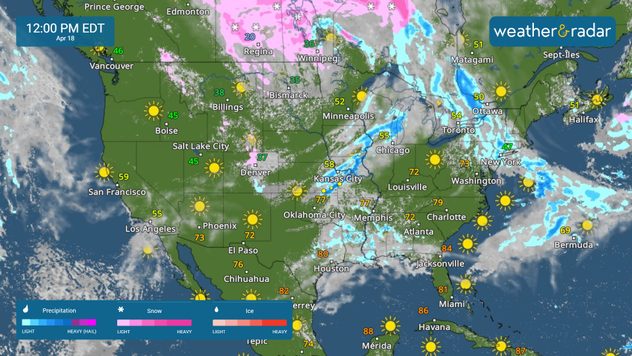
Home
Weather New York
WeatherRadar
RainRadar
TemperatureRadar
WindRadar
LightningRadar
Weather News
Editor's Pick
Discover the app
Weather widget
Contact us
Apps
Career
    Home / Weather News /

    Breakfast brief: Storm threat S. Plains to Ohio Valley

09:00 AM
April 18, 2024

Breakfast brief
Storm threat S. Plains to Ohio Valley

Strong to severe storms are possible from the southern Plains into the lower Ohio Valley. As low pressure moves into Canada, there will be a few lingering snow showers across the northern Plains and upper Mid-West.

Coldest April temperature on record

The temperature at Eagles Nest, NM, plunged to 45 degrees below zero to establish an April record for the United States.

Today's weather outlook

As a surface front moves east, scattered showers and storms are expected to develop along the boundary. Severe storms are possible from Texas into the Ohio Valley. All types of severe weather are possible, with the greatest risk in southeastern Missouri, northwestern Tennessee, western Kentucky, and southern Illinois. Damaging winds, hail, and tornadoes are possible.

WeatherRadar April 18

The WeatherRadar shows a few lingering snow showers across the northern Plains and northern Minnesota as the low pressure exits into Canada.

News we're covering today:

  • Severe threat stretches across the southern Plains into the Ohio Valley.
  • Warm weather across the South.

Did you miss these?

Dubai floodedread more
Coral Bleachingread more
Solar storm brought Midwest aurorasread more

App news & updates:

Lightning can be deadly! When thunder roars, it's best to head indoors. Want to know how close you are to lightning strikes? Take a look at our LightningRadar and click the link below to learn how to calculate how close a lightning strike is to you.

Is lightning too close?read more
More on the topic
Heat wave setting records across Europe. London breaks May record. . . Tuesday, May 26, 2026
European heat wave
Tuesday, May 26, 2026

London breaks May record

Heat wave setting records across Europe
High pressure & extreme heat. Why & how does it work?. . . Sunday, April 19, 2026
Sunday, April 19, 2026

Why & how does it work?

High pressure & extreme heat
El Niño is gaining momentum. Temperature records?. . . Thursday, May 7, 2026
The image shows the central Pacific in a computer model. A striking feature is the ocean coloured red, which indicates very warm seawater.
Thursday, May 7, 2026

Temperature records?

El Niño is gaining momentum
All weather news
This might also interest you
Arthur forms. Gulf Coast soaker. . . Wednesday, June 17, 2026
Arthur forms
Wednesday, June 17, 2026

Gulf Coast soaker

Arthur forms
Double-whammy severe storm threat. Illinois & Indiana. . . Wednesday, June 17, 2026
Wednesday, June 17, 2026

Illinois & Indiana

Double-whammy severe storm threat
Low pressure triggers stormy skies. Midwest. . . Tuesday, June 16, 2026
Tuesday, June 16, 2026

Midwest

Low pressure triggers stormy skies
All articles
Weather & Radar

Weather & Radar is also available on

Google Play StoreApp Store

Company

Contact us Privacy policy Legal info Accessibility statement

Services

Uploader

Socials

instagramfacebookthreadslinkList