Home
Weather New York
WeatherRadar
RainRadar
TemperatureRadar
WindRadar
LightningRadar
Weather News
Editor's Pick
Discover the app
Weather widget
Contact us
Apps
Career
    Home / Editor's Pick /

    Breakfast Brief: Tropical system brings Texas flood threat

09:00 AM
June 19, 2024

Breakfast brief
Tropical system & Texas flood threat

Rainbands from Potential Tropical Cyclone One will continue to push across eastern Texas and Louisiana today, increasing flash flood risk across the region. To the north, a potent heat wave intensifies across the Northeast as record-high temperatures continue to be broken.

Today's weather outlook

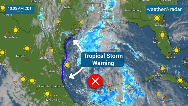
A tropical system nearing the Mexican coast will continue to spread heavy rainbands across portions of the Texas and western Louisiana coastline. These rainbands will carry heavy showers and gusty conditions. Some showers will be particularly intense or long-lasting which will increase flash flood risk. See what areas are at greatest risk.

To the north, a life-threatening heat wave is underway across the eastern U.S., with temperatures potentially reaching the triple digits in the Northeast by Thursday or Friday. Many locations across the region will see or at least approach daily temperature high records that were set back in the early 1950s, marking the significance of this event.

tropical storm warning

In contrast to the extreme heat across the Northeast, the Northwest will remain cold, windy, rainy, and even snowy in the mountains through today. A warming trend is set to take over starting tomorrow, bringing temperatures back to normal or even slightly above average by the weekend.

Tropical update

Potential Tropical Cyclone One is moving west across the southern Gulf of Mexico, nearing the eastern Mexican coast. The system will be in a pocket of favorable conditions for intensification, and a tropical storm may form by late Tuesday or early Wednesday. Regardless of its exact tract, the system will spread heavy tropical downpours across the northwest Gulf Coast, including portions of Texas and Louisiana, increasing flash flood risk across the region through Thursday.

Another area of potential development is located several hundred miles east of the Bahamas. The system is forecast to approach the coast of the southeast United States on Thursday or Friday, though the chances of development into a tropical cyclone remain low.

The news we're covering today:

  • Potential first named storm of the season nears Texas
  • Life-threatening heat wave expands across the Northeast

Did you miss these?

Big Ozone layer improvementread more
Noctilucent clouds returnread more
9 tips to stay safe from the heatread more
2024 Hurricane Season forecast updateread more
Preparing for 2024 hurricane seasonread more

App news & updates:

Did you know you can receive notifications for incoming tropical systems? Our storm alert feature keeps you informed about dangerous winds, heavy rain, or storm surge in your area. Simply turn on your alerts to stay updated. Find out how here.

Federico Di Catarina
More on the topic
Rip currents & safety tips. As more head to the coast. . . Sunday, July 5, 2026
rip current
Sunday, July 5, 2026

As more head to the coast

Rip currents & safety tips
Super Typhoon Bavi threatens Taiwan. 155 mph winds. . Weather Videos. Wednesday, July 8, 2026
The image shows an intense tropical cyclone over the western Pacific, east of Taiwan and the Philippines. The centre of the system is depicted as a light purple and white vortex with a clearly visible eye, surrounded by a ring of red and orange areas indicating the strongest wind speeds. A white arrow marks the typhoon’s predicted track towards the north-west, in the direction of Taiwan. To the west of the storm lie the Philippines, with the cities of Manila and Cebu; to the north of these lies Taiwan, with Taipei. Further west, the Chinese coast, including Hong Kong, and parts of Vietnam can be seen. The coloured wind map shows predominantly green areas outside the storm’s core, indicating significantly weaker winds. White streamlines illustrate the typhoon’s anti-clockwise circulation in the Northern Hemisphere. The highest wind speeds are concentrated around the eye of the cyclone.
Weather VideosWednesday, July 8, 2026

155 mph winds

Super Typhoon Bavi threatens Taiwan
Meteorological summer is here!. Bye, spring!. . . Monday, June 1, 2026
Monday, June 1, 2026

Bye, spring!

Meteorological summer is here!
All weather news
This might also interest you
Area to watch this weekend. Tropical trouble?. . . Wednesday, July 15, 2026
An area of low pressure is expected to develop this weekend off Florida's Big Bend. The question is: will this mean tropical trouble for the Southeast?
Wednesday, July 15, 2026

Tropical trouble?

Area to watch this weekend
Year's worth of rainfall piling up. Southwest Texas. . . Thursday, July 16, 2026
Extreme weather alerts active in Southwest Texas.
Thursday, July 16, 2026

Southwest Texas

Year's worth of rainfall piling up
When severe storms strike.... You can be ready. . . Saturday, July 18, 2026
Saturday, July 18, 2026

You can be ready

When severe storms strike...
All articles
Weather & Radar

Weather & Radar is also available on

Google Play StoreApp Store

Company

Contact us Privacy policy Legal info Accessibility statement

Services

Uploader

Socials

instagramfacebookthreadslinkList