Home
Weather New York
WeatherRadar
RainRadar
TemperatureRadar
WindRadar
LightningRadar
Weather News
Editor's Pick
Discover the app
Weather widget
Contact us
Apps
Career
    Home / Weather News /

    Bringing rain & storms - Three lows march on the WeatherRadar

03:02 PM
May 22, 2026

Bringing rain & storms
Three lows march on the WeatherRadar

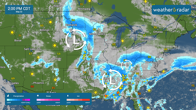
Three low-pressure systems are showing up on the WeatherRadar on Friday, bringing a soggy and stormy forecast with them.

The WeatherRadar shows three distinct low pressures with their outskirts drenched with rain and storms.

Three low-pressure systems bringing heavy, even flooding, rains across the eastern two-thirds.

As these lows tap into abundant moisture across the eastern two-thirds, heavy rains are set to cause flash flooding, especially in places that have been experiencing drought conditions for months now.

Oklahoma, the Deep South to the Ohio Valley and parts of the Carolinas, especially along the Appalachian spine, are expected to see rains that could cause flash flooding.

Upload and send us your views of the heavy rainfall in your area!

Becca Parker
More on the topic
The best views of Wednesday's eclipse. Europe's sky show. . . Thursday, August 13, 2026
Solar eclipse: The sun obscured between wind turbines in Sardinia
Thursday, August 13, 2026

Europe's sky show

The best views of Wednesday's eclipse
Super Typhoon Bavi threatens Taiwan. 155 mph winds. . Weather Videos. Wednesday, July 8, 2026
The image shows an intense tropical cyclone over the western Pacific, east of Taiwan and the Philippines. The centre of the system is depicted as a light purple and white vortex with a clearly visible eye, surrounded by a ring of red and orange areas indicating the strongest wind speeds. A white arrow marks the typhoon’s predicted track towards the north-west, in the direction of Taiwan. To the west of the storm lie the Philippines, with the cities of Manila and Cebu; to the north of these lies Taiwan, with Taipei. Further west, the Chinese coast, including Hong Kong, and parts of Vietnam can be seen. The coloured wind map shows predominantly green areas outside the storm’s core, indicating significantly weaker winds. White streamlines illustrate the typhoon’s anti-clockwise circulation in the Northern Hemisphere. The highest wind speeds are concentrated around the eye of the cyclone.
Weather VideosWednesday, July 8, 2026

155 mph winds

Super Typhoon Bavi threatens Taiwan
How does fog form?. Multiple ways. . . Saturday, July 11, 2026
Saturday, July 11, 2026

Multiple ways

How does fog form?
All weather news
This might also interest you
Understanding the feels like temperature. Advanced heat measurement. . . Saturday, August 15, 2026
feels like temperature
Saturday, August 15, 2026

Advanced heat measurement

Understanding the feels like temperature
Hurricane Lala passes south of the Big Island. Flooding, wind in Hawaii. . . Sunday, August 16, 2026
Lala will continue to downgrade and pass south of the rest of the Hawaiian islands.
Sunday, August 16, 2026

Flooding, wind in Hawaii

Hurricane Lala passes south of the Big Island
Rainfall deficit tops a foot. Southeast Florida. . . Tuesday, August 18, 2026
All heat and no rain for Southeast Florida today.
Tuesday, August 18, 2026

Southeast Florida

Rainfall deficit tops a foot
All articles
Weather & Radar

Weather & Radar is also available on

Google Play StoreApp Store

Company

Contact us Privacy policy Legal info Accessibility statement

Services

Uploader

Socials

instagramfacebookthreadslinkList