Home
Weather New York
WeatherRadar
RainRadar
TemperatureRadar
WindRadar
LightningRadar
Weather News
Editor's Pick
Discover the app
Weather widget
Contact us
Apps
Career
    Home / Editor's Pick /

    Central Plains & Midwest: severe risk intensifies & expands

05:30 PM
April 30, 2024

Central Plains & Midwest
Severe risk intensifies & expands

As highlighted in yesterday's briefing, this week's forecast predicts continued severe weather in areas already impacted over the weekend. The risk has intensified and expanded.

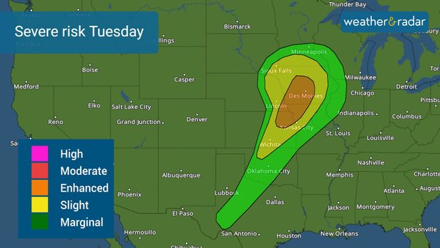
A low-pressure system moves over the Northern Plains and into the Great Lakes area. A cold front extends to the southern Plains, and it seems like this system is coming in stronger, so the risk has increased to a level 3 of 5 across parts of southwestern Iowa, northeastern Kansas, northwestern Missouri, and extreme southeastern Nebraska.

Around this enhanced risk, there is a slight risk that covers parts of the Central Plains and Midwest in a level 2 out of 5 of experiencing severe weather. Thunderstorms could bring damaging winds, large hail, and even a few tornadoes. If you are in an area highlighted orange or yellow, you should be weather aware and have a plan to head to a safe shelter when severe thunderstorms and tornado warnings are issued.

The Midwest is under a slight risk of severe storms. A few tornadoes are possible.

On Wednesday afternoon and Thursday morning, another system exits the Rockies intensifying. It is possible that with the forecast setup, including a dry line in the recipe interacting with the complex system, the risk will expand, but it also has the potential to increase over the Central Plains, including Texas. As of Monday morning, there is a slight risk for much of Kansas, central Oklahoma, and a portion of northwestern Texas.

The system itself will merge to the north of the Great Lakes area but the front will expand and extend to South Texas by Friday. This means that there will likely be days of rain for Texas as the front slowly moves east, especially for the east and south regions of the Lone Star State.

We will bring you prompt updates and continue to fine-tune the forecast. Please stay informed.

Irene Sans
More on the topic
Longest day of the year is here. Summer solstice. . . Sunday, June 21, 2026
Sunday, June 21, 2026

Summer solstice

Longest day of the year is here
Record-breaking heatwave in Europe. Hotter than most of U.S.. . . Thursday, June 25, 2026
Thursday, June 25, 2026

Hotter than most of U.S.

Record-breaking heatwave in Europe
Europe: Warmest June on record. Warm waters too. . . Friday, July 10, 2026
The record-breaking heatwave in June has made climate history in Western Europe.
Friday, July 10, 2026

Warm waters too

Europe: Warmest June on record
All weather news
This might also interest you
Multi-Day flood threat for Mid-Atlantic. Stalled front. . . Wednesday, July 22, 2026
Wednesday, July 22, 2026

Stalled front

Multi-Day flood threat for Mid-Atlantic
Heat indices soaring. High humidity. . . Saturday, July 25, 2026
Saturday, July 25, 2026

High humidity

Heat indices soaring
How does a hurricane form?. Hurricane preparedness. . . Sunday, July 19, 2026
hurricane maria
Sunday, July 19, 2026

Hurricane preparedness

How does a hurricane form?
All articles
Weather & Radar

Weather & Radar is also available on

Google Play StoreApp Store

Company

Contact us Privacy policy Legal info Accessibility statement

Services

Uploader

Socials

instagramfacebookthreadslinkList