Home
Weather New York
WeatherRadar
RainRadar
TemperatureRadar
WindRadar
LightningRadar
Weather News
Editor's Pick
Discover the app
Weather widget
Contact us
Apps
Career
    Home / Weather News /

    Closer look at temps: Cooler-than-average East, warmer South

03:16 PM
May 30, 2024

Closer look at temps
Cooler-than-average East, warmer South

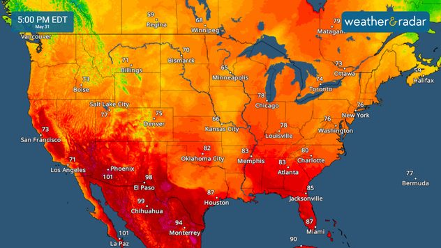
Cooler-than-average temperatures are in the forecast for the Northeast into the weekend, while parts of the South stay steamy

As we close out the month of May, some parts of the U.S. will see cooler-than-average temperatures, while others will experience more summer-like conditions.

TemperatureRadar

While the central Plains often experiences hot temperatures this time of year, stormy weather will hold high temperatures in the 70s and 80s in cities like Wichita, Kan., Oklahoma City, Dallas, and Houston. Further south and west, temperatures will soar into the 90s in cities like San Antonio. The Southwest will get even hotter, with triple digits in Phoenix.

Severe threat for Texas, New Mexicoread more

Steamy temperatures are also in play for the Sunshine State with highs reaching the 90s in Tampa, Orlando, and Fort Myers, Fla. A cold front will arrive Saturday and finally bring some relief to the peninsula, but until then the only respite from the heat will be in the form of an afternoon thunderstorm.

High pressure over the lower Great Lakes and Ohio Valley will help keep temperatures refreshing across much of the East. The Northeast will be comfortable with afternoon highs in the 60s and 70s in cities like Boston and New York City. The Mid-Atlantic will see highs in the 70s, while the Southeast will be warmer in the low to mid-80s.

While many spots will stay comfortable into the weekend, summer heat is just around the bend. Keep an eye on the TemperatureRadar for the latest.

More on the topic
Super Typhoon Near the Philippines. Gusts up to 155. . . Tuesday, June 23, 2026
Tuesday, June 23, 2026

Gusts up to 155

Super Typhoon Near the Philippines
How does fog form?. Multiple ways. . . Saturday, July 11, 2026
Saturday, July 11, 2026

Multiple ways

How does fog form?
Super Typhoon Bavi threatens Taiwan. 155 mph winds. . Weather Videos. Wednesday, July 8, 2026
The image shows an intense tropical cyclone over the western Pacific, east of Taiwan and the Philippines. The centre of the system is depicted as a light purple and white vortex with a clearly visible eye, surrounded by a ring of red and orange areas indicating the strongest wind speeds. A white arrow marks the typhoon’s predicted track towards the north-west, in the direction of Taiwan. To the west of the storm lie the Philippines, with the cities of Manila and Cebu; to the north of these lies Taiwan, with Taipei. Further west, the Chinese coast, including Hong Kong, and parts of Vietnam can be seen. The coloured wind map shows predominantly green areas outside the storm’s core, indicating significantly weaker winds. White streamlines illustrate the typhoon’s anti-clockwise circulation in the Northern Hemisphere. The highest wind speeds are concentrated around the eye of the cyclone.
Weather VideosWednesday, July 8, 2026

155 mph winds

Super Typhoon Bavi threatens Taiwan
All weather news
This might also interest you
Northern New England storms. Rare severe threat. . . Tuesday, July 14, 2026
Tuesday, July 14, 2026

Rare severe threat

Northern New England storms
Year's worth of rainfall piling up. Southwest Texas. . . Thursday, July 16, 2026
Extreme weather alerts active in Southwest Texas.
Thursday, July 16, 2026

Southwest Texas

Year's worth of rainfall piling up
Dangerous air quality continues. Canada wildfires smoke. . . Friday, July 17, 2026
Smoky Philadelphia
Friday, July 17, 2026

Canada wildfires smoke

Dangerous air quality continues
All articles
Weather & Radar

Weather & Radar is also available on

Google Play StoreApp Store

Company

Contact us Privacy policy Legal info Accessibility statement

Services

Uploader

Socials

instagramfacebookthreadslinkList