Home
Weather New York
WeatherRadar
RainRadar
TemperatureRadar
WindRadar
LightningRadar
Weather News
Editor's Pick
Discover the app
Weather widget
Contact us
Apps
Career
    Home / Editor's Pick /

    Cold plunge for East, West's atmospheric river

10:00 AM
November 20, 2024

Breakfast Brief
Cold for East, West's atmospheric river

While the strong cold front continues to impact the Southeast on Wednesday, we are monitoring the next incoming winter storm and atmospheric rivers that will wreak havoc in the West. The Breakfast Brief is published every Monday through Friday at 5 a.m. ET.

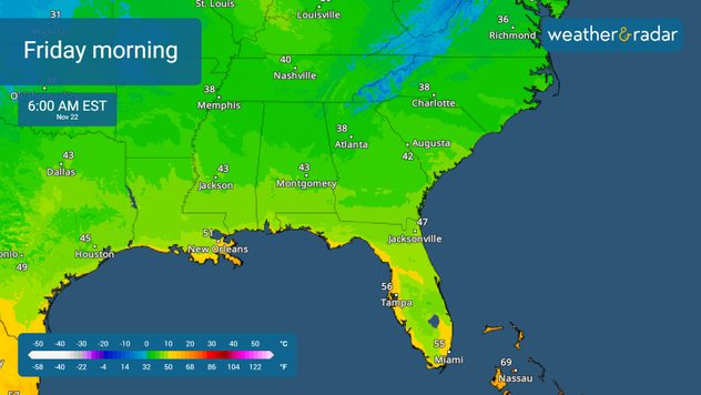
Some strong isolated storms will move across Florida on Wednesday, pushed by a strong cold front that promises to bring the coldest temperatures of the season so far to the end of the week. The good news is that the deeper moisture that produced stronger downpours on Tuesday seems to be winding down, and showers will not be as intense for the Southeast and more isolated in nature.

1/3

Showers will extend through the Mid-Atlantic, and as the system breaks in two, another low-pressure system will travel over the Northeast late Wednesday into Thursday. This system will continue producing winter precipitation as cold air filters through the Great Lakes and interior Northeast. Winds will also pick up and continue to be strong through the end of the week.

An atmospheric river enters the Pacific Northwest. This channel of deep moisture will pose a high risk for flash floods across northern California and southwestern Oregon on Wednesday and Thursday. Plan carefully; these rains and heavy mountain snow could produce landslides. Power outages are possible, our WindRadar shows gusts that could exceed 50 mph. Keep your app alerts on and have at least three ways to receive a weather warning.

November 20, 2015

Season's first snow is Chicago's largest November snowfall in 120 years starting on November 20 and ending on the 21st. The season's first snowfall dropped as much as 17 inches across Chicago's northern suburbs, and the total of 11.2 inches at O'Hare International Airport.

Tropical update:

Woohoo! No areas are currently being monitored over the Atlantic Basin.

News we are covering today:

  • Wind & cold temperatures arrive to the East.
  • Atmospheric river enters the west, high flood threat

Did you miss these?

Your all-in-one astronomy toolread more
A town that uses mirrors for sunlightread more

App news & updates:

Thanksgiving is around the corner! Tune in to our YouTube page on November 25, 26 and 27, 2024 for live travel forecasts.

Irene Sans
More on the topic
Rip currents & safety tips. As more head to the coast. . . Sunday, July 5, 2026
rip current
Sunday, July 5, 2026

As more head to the coast

Rip currents & safety tips
Super Typhoon Bavi threatens Taiwan. 155 mph winds. . Weather Videos. Wednesday, July 8, 2026
The image shows an intense tropical cyclone over the western Pacific, east of Taiwan and the Philippines. The centre of the system is depicted as a light purple and white vortex with a clearly visible eye, surrounded by a ring of red and orange areas indicating the strongest wind speeds. A white arrow marks the typhoon’s predicted track towards the north-west, in the direction of Taiwan. To the west of the storm lie the Philippines, with the cities of Manila and Cebu; to the north of these lies Taiwan, with Taipei. Further west, the Chinese coast, including Hong Kong, and parts of Vietnam can be seen. The coloured wind map shows predominantly green areas outside the storm’s core, indicating significantly weaker winds. White streamlines illustrate the typhoon’s anti-clockwise circulation in the Northern Hemisphere. The highest wind speeds are concentrated around the eye of the cyclone.
Weather VideosWednesday, July 8, 2026

155 mph winds

Super Typhoon Bavi threatens Taiwan
How does fog form?. Multiple ways. . . Saturday, July 11, 2026
Saturday, July 11, 2026

Multiple ways

How does fog form?
All weather news
This might also interest you
Area to watch this weekend. Tropical trouble?. . . Wednesday, July 15, 2026
An area of low pressure is expected to develop this weekend off Florida's Big Bend. The question is: will this mean tropical trouble for the Southeast?
Wednesday, July 15, 2026

Tropical trouble?

Area to watch this weekend
Be prepared for wildfires. By using the app. . . Saturday, July 18, 2026
Wildfires can spark anywhere, anytime. The Weather & Radar app can help you determine your area's risk.
Saturday, July 18, 2026

By using the app

Be prepared for wildfires
Dangerous air quality continues. Canada wildfires smoke. . . Friday, July 17, 2026
Smoky Philadelphia
Friday, July 17, 2026

Canada wildfires smoke

Dangerous air quality continues
All articles
Weather & Radar

Weather & Radar is also available on

Google Play StoreApp Store

Company

Contact us Privacy policy Legal info Accessibility statement

Services

Uploader

Socials

instagramfacebookthreadslinkList