Home
Weather New York
WeatherRadar
RainRadar
TemperatureRadar
WindRadar
LightningRadar
Weather News
Editor's Pick
Discover the app
Weather widget
Contact us
Apps
Career
    Home / Weather News /

    Cross country storm

03:57 PM
December 17, 2025

Coast-to-coast impacts
Cross country storm

A powerful storm will move across the country this week, bringing rain, snow and high winds.

The WeatherRadar shows a powerful storm moving out of the Northwest and into the northern Plains and Rockies today. Hundreds of thousands of customers are without power in parts of Washington, Oregon and Idaho after powerful winds blasted through the region.

This system will bring rain to the lower elevations and snow to the mountains and higher elevations today across parts of the Northwest, northern Plains and northern Rockies. Heavy mountain snow amounting to 1-3 feet through Thursday, will make travel difficult along mountain passes in the Rockies and Cascades.

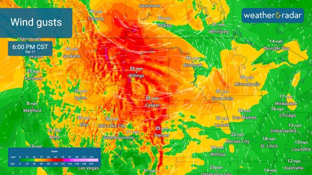
The WindRadar shows high winds moving from the Northwest into the Plains and Rockies.

High winds will also bring their own issues. The WindRadar shows 50-70 mph gusts, with gusts upwards of 80 mph across higher elevations and downwind areas of those elevations. These high wind gusts will increase fire danger along Colorado's Front Range, including in cities like Denver and Colorado Springs.

Blowing snow across the northern Plains will also pose a significant travel threat. Snow bands and gusty winds will create whiteout conditions tonight into Thursday. Keep an eye on the development of this system with the WindRadar and the WeatherRadar.

Mary Mays
More on the topic
How does fog form?. Multiple ways. . . Saturday, September 12, 2026
Saturday, September 12, 2026

Multiple ways

How does fog form?
Record ocean heat halting hurricanes. Strong El Niño influence. . . Sunday, September 13, 2026
A weather map shows a calm Atlantic Ocean with no hurricanes, alongside a picture of the sea.
Sunday, September 13, 2026

Strong El Niño influence

Record ocean heat halting hurricanes
All about nocturnal severe weather. Risks & preparedness. . . Saturday, September 5, 2026
Saturday, September 5, 2026

Risks & preparedness

All about nocturnal severe weather
All weather news
This might also interest you
Autumn cold front arrives. October cooldown spreads. . . Friday, October 2, 2026
Cold front brings cooler temperatures.
Friday, October 2, 2026

October cooldown spreads

Autumn cold front arrives
Be ready for tropical activity. Tips & tools. . . Wednesday, October 7, 2026
Track hurricanes with the WeatherRadar
Wednesday, October 7, 2026

Tips & tools

Be ready for tropical activity
40-degree difference over 101 miles. Eureka to Redding. . . Tuesday, October 6, 2026
Tuesday, October 6, 2026

Eureka to Redding

40-degree difference over 101 miles
All articles
Weather & Radar

Weather & Radar is also available on

Google Play StoreApp Store

Company

Contact us Privacy policy Legal info Accessibility statement

Services

Uploader

Socials

instagramfacebookthreadslinkList