Home
Weather New York
WeatherRadar
RainRadar
TemperatureRadar
WindRadar
LightningRadar
Weather News
Editor's Pick
Discover the app
Weather widget
Contact us
Apps
Career
    Home / Weather News /

    Cyclonic development over the Gulf is intensifying

12:41 AM
July 20, 2026

It moves slowly
Gulf system is becoming better organized

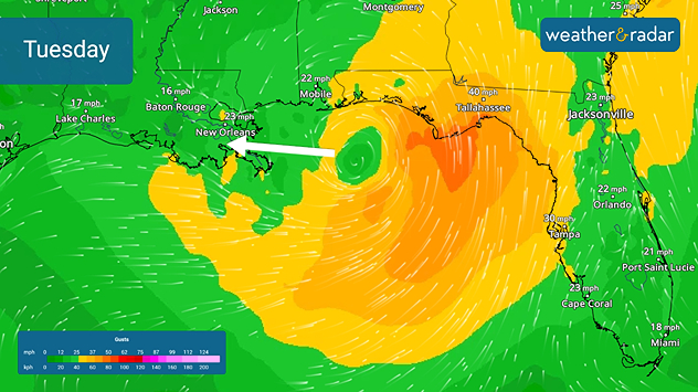
On Sunday, the second tropical depression of the 2026 Atlantic hurricane season officially formed. The system is trying to strengthen and could become Bertha today as it moves slowly across the northeastern Gulf.

The slow movement of this storm is due to it being trapped between two high-pressure systems: one over the western Atlantic and another extending toward the central United States. The system is expected to move slightly to the northwest today and Tuesday. Later Tuesday into Wednesday, it will begin moving westward more rapidly.

The WindRadar shows the system's wind filed on Tuesday. It is likely to become better organized and possibly be a tropical storm by then.

For now, the official track and our WeatherRadar indicate that the storm will move into southeastern Louisiana near the mouth of the Mississippi River Wednesday, moving along the southern Louisiana coast on Thursday before fading over eastern Texas later this week.

This storm is moving through warm waters, with temperatures even above the seasonal average, ranging from 85 to 87 °F. These temperatures are fueling the system. Although there are signs that wind shear will increase in this region—which would limit the storm’s intensification—we must remain very vigilant about its development. Torrential rain, storm surge, and strong winds are expected, especially along the Gulf Coast. Flooding could become a serious issue with this slow-moving system.

Irene Sans
More on the topic
Europe: Warmest June on record. Warm waters too. . . Friday, July 10, 2026
The record-breaking heatwave in June has made climate history in Western Europe.
Friday, July 10, 2026

Warm waters too

Europe: Warmest June on record
Longest day of the year is here. Summer solstice. . . Sunday, June 21, 2026
Sunday, June 21, 2026

Summer solstice

Longest day of the year is here
Super Typhoon Near the Philippines. Gusts up to 155. . . Tuesday, June 23, 2026
Tuesday, June 23, 2026

Gusts up to 155

Super Typhoon Near the Philippines
All weather news
This might also interest you
Area to watch this weekend. Tropical trouble?. . . Wednesday, July 15, 2026
An area of low pressure is expected to develop this weekend off Florida's Big Bend. The question is: will this mean tropical trouble for the Southeast?
Wednesday, July 15, 2026

Tropical trouble?

Area to watch this weekend
Northern New England storms. Rare severe threat. . . Tuesday, July 14, 2026
Tuesday, July 14, 2026

Rare severe threat

Northern New England storms
Wildfire smoke travels 1K+ miles. Canada to Mid-Atlantic. . . Tuesday, July 14, 2026
Tuesday, July 14, 2026

Canada to Mid-Atlantic

Wildfire smoke travels 1K+ miles
All articles
Weather & Radar

Weather & Radar is also available on

Google Play StoreApp Store

Company

Contact us Privacy policy Legal info Accessibility statement

Services

Uploader

Socials

instagramfacebookthreadslinkList