Home
Weather New York
WeatherRadar
RainRadar
TemperatureRadar
WindRadar
LightningRadar
Weather News
Editor's Pick
Discover the app
Weather widget
Contact us
Apps
Career
    Home / Weather News /

    Daily briefing

10:00 AM
October 28, 2025

Daily briefing
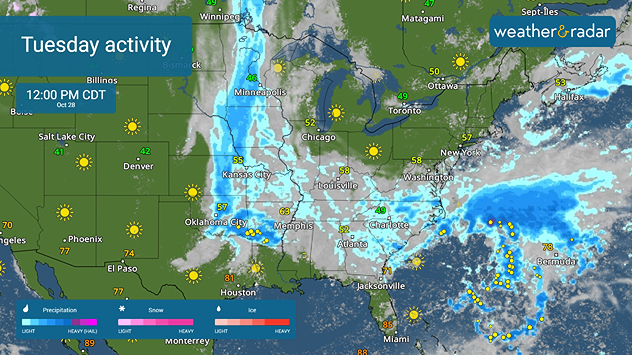
Active Tuesday ahead for many

Multiple storm systems will bring rain and storms to the U.S. today. Plus, Major Hurricane Melissa is headed for landfall in Jamaica. This, along with our tropical update, is available at 5 a.m. ET in our daily briefing.

An active morning is already underway from the Upper Midwest to Oklahoma as rains drench the commute. Thunderstorms are also possible within too. This will continue throughout the day, later including the lower Mississippi Valley with embedded thunderstorms.

Further to the east, scattered rains are impacting those in the lower Ohio Valley down to the Southeast today. Keep the umbrella handy!

Rain and thuderstorms spread into much of the eastern half of the U.S.

Although much of the West is quiet today, we have another storm approaching the Pacific Northwest. Rain and upper elevation snow and ice are all possible starting late this morning. Watch this storm on the WeatherRadar.

A cool Tuesday is in store for many. Upper 40s and 50s will spread across the Midwest to as far south as Macon, Ga., and northward through the Northeast. Temperatures in the 50s and 60s will be found from Denver to Lubbock, Texas, and east to Nashville as well as in the Pacific Northwest. The Rockies stay chilly in the 40s or lower, but the warmest weather will be felt in California, the Southwest, the southern tier and Florida in the 70s and 80s, with the 90s being found in the Desert Southwest and South Texas.

Tropical Update

Major Hurricane Melissa is expected to make landfall in Jamaica today, dropping flooding rains of 20 to 30 inches by the time it makes its way through. Extreme winds of at least 150 mph near the center of Melissa are possible, with higher gusts. Watch it closely on the WeatherRadar.

We continue to monitor the tropics as the Atlantic Hurricane Season lasts until November 30.

App News

If you are (or input a location) within 5 miles of the coast, you can see the marine conditions as well as the high and low tide times, here.

Becca Parker
More on the topic
Heat wave setting records across Europe. London breaks May record. . . Tuesday, May 26, 2026
European heat wave
Tuesday, May 26, 2026

London breaks May record

Heat wave setting records across Europe
High pressure & extreme heat. Why & how does it work?. . . Sunday, June 28, 2026
Sunday, June 28, 2026

Why & how does it work?

High pressure & extreme heat
Super Typhoon Bavi threatens Taiwan. 155 mph winds. . Weather Videos. Wednesday, July 8, 2026
The image shows an intense tropical cyclone over the western Pacific, east of Taiwan and the Philippines. The centre of the system is depicted as a light purple and white vortex with a clearly visible eye, surrounded by a ring of red and orange areas indicating the strongest wind speeds. A white arrow marks the typhoon’s predicted track towards the north-west, in the direction of Taiwan. To the west of the storm lie the Philippines, with the cities of Manila and Cebu; to the north of these lies Taiwan, with Taipei. Further west, the Chinese coast, including Hong Kong, and parts of Vietnam can be seen. The coloured wind map shows predominantly green areas outside the storm’s core, indicating significantly weaker winds. White streamlines illustrate the typhoon’s anti-clockwise circulation in the Northern Hemisphere. The highest wind speeds are concentrated around the eye of the cyclone.
Weather VideosWednesday, July 8, 2026

155 mph winds

Super Typhoon Bavi threatens Taiwan
All weather news
This might also interest you
100 miles, 30-degree difference. Southern California. . . Thursday, July 9, 2026
Thursday, July 9, 2026

Southern California

100 miles, 30-degree difference
Saharan dust to reach Florida. Dry period expected. . . Tuesday, July 7, 2026
Saharan dust seen on the satllite image (right) moving westward toward Florida. Air quality impacts are expected.
Tuesday, July 7, 2026

Dry period expected

Saharan dust to reach Florida
Understanding the feels like temperature. Advanced heat measurement. . . Friday, July 3, 2026
feels like temperature
Friday, July 3, 2026

Advanced heat measurement

Understanding the feels like temperature
All articles
Weather & Radar

Weather & Radar is also available on

Google Play StoreApp Store

Company

Contact us Privacy policy Legal info Accessibility statement

Services

Uploader

Socials

instagramfacebookthreadslinkList