Home
Weather New York
WeatherRadar
RainRadar
TemperatureRadar
WindRadar
LightningRadar
Weather News
Editor's Pick
Discover the app
Weather widget
Contact us
Apps
Career
    Home / Weather News /

    Daily briefing: Christmas forecast

10:00 AM
December 25, 2025

Daily briefing
Christmas forecast

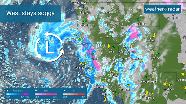
Christmas is going to be a soggy one for large stretches of the western U.S. today, with a few trouble spots found across the U.S. This is included in today's Christmas daily briefing, published every weekday at 5 a.m. ET.

The West remains locked in a soggy pattern today. The WeatherRadar shows heavy rain continuing across California, with the rain expanding into the Southwest and southern Rockies and the Pacific Northwest. Skiers will rejoice across the Sierras and the highest Rockies as significant snow falls in the highest elevations.

West Coast trouble
Heavy rain continues across the West.

Across the Ohio Valley into the southern Mid-Atlantic, a small storm system will produce a few showers while a second small system brings snow chances to northern New England.

The rest of the U.S. will have a quiet Christmas day, with the TemperatureRadar showing near record highs across the southern Plains and the Southeast as highs jump into the upper 70s. The Ohio Valley and the Mid-Atlantic will also be mild with highs in the 60s.

The northern tier will not be so lucky, with highs in the 20s and 30s, and a few Midwest spots hitting the low 40s.

App News

Making post-holiday plans? Want to know how the Weather & Radar app can help? You can see all of our features at a glance using the Discover the App feature.

James West
More on the topic
Europe: Warmest June on record. Warm waters too. . . Friday, July 10, 2026
The record-breaking heatwave in June has made climate history in Western Europe.
Friday, July 10, 2026

Warm waters too

Europe: Warmest June on record
Record-breaking heatwave in Europe. Hotter than most of U.S.. . . Thursday, June 25, 2026
Thursday, June 25, 2026

Hotter than most of U.S.

Record-breaking heatwave in Europe
Super Typhoon Bavi threatens Taiwan. 155 mph winds. . Weather Videos. Wednesday, July 8, 2026
The image shows an intense tropical cyclone over the western Pacific, east of Taiwan and the Philippines. The centre of the system is depicted as a light purple and white vortex with a clearly visible eye, surrounded by a ring of red and orange areas indicating the strongest wind speeds. A white arrow marks the typhoon’s predicted track towards the north-west, in the direction of Taiwan. To the west of the storm lie the Philippines, with the cities of Manila and Cebu; to the north of these lies Taiwan, with Taipei. Further west, the Chinese coast, including Hong Kong, and parts of Vietnam can be seen. The coloured wind map shows predominantly green areas outside the storm’s core, indicating significantly weaker winds. White streamlines illustrate the typhoon’s anti-clockwise circulation in the Northern Hemisphere. The highest wind speeds are concentrated around the eye of the cyclone.
Weather VideosWednesday, July 8, 2026

155 mph winds

Super Typhoon Bavi threatens Taiwan
All weather news
This might also interest you
20 days of at least 100°F. Southern Plains. . . Thursday, August 20, 2026
Thursday, August 20, 2026

Southern Plains

20 days of at least 100°F
Gravity wave clouds explained. The ideal conditions. . . Saturday, August 22, 2026
Saturday, August 22, 2026

The ideal conditions

Gravity wave clouds explained
Gravity wave spotted on WeatherRadar. Moving into TN. . . Monday, August 17, 2026
Monday, August 17, 2026

Moving into TN

Gravity wave spotted on WeatherRadar
All articles
Weather & Radar

Weather & Radar is also available on

Google Play StoreApp Store

Company

Contact us Privacy policy Legal info Accessibility statement

Services

Uploader

Socials

instagramfacebookthreadslinkList