Home
Weather New York
WeatherRadar
RainRadar
TemperatureRadar
WindRadar
LightningRadar
Weather News
Editor's Pick
Discover the app
Weather widget
Contact us
Apps
Career
    Home / Weather News /

    Daily briefing: Flood risk for the Mississippi Valley

09:00 AM
August 28, 2025

Daily Briefing
Flood risk for the Mississippi Valley

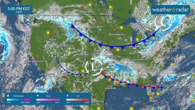
The threat of flooding extends from the Central Plains to the Mississippi Valley. Cooler-than-average temperatures linger for much of the lower 48. These details, along with our daily tropical outlook, are published every weekday at 5 a.m. ET.

The WeatherRadar shows showers and storms stretching across portions of the Plains and Mississippi Valley today. Flash flooding will be possible in cities such as Colorado Springs, Colo., Tulsa, Okla., Fayetteville, Ark., Greenville, Miss., and Memphis, Tenn., where rainfall rates of 2 to 3 inches per hour are possible.

The WeatherRadar also shows a few showers in the eastern Great Lakes and interior Northeast, as well as in the Intermountain West. Dry lightning in the Pacific Northwest may spark a wildfire.

Cooler-than-average temperatures are sticking around across much of the country, with some exceptions. It will be a cool start in parts of the Ohio Valley, Mid-South and Mid-Atlantic, with temperatures dipping into the 40s and 50s. Highs will reach the 70s and 80s across the same regions this afternoon.

The TemperatureRadar shows heat building across the Pacific Northwest and Texas. The Northwest remains above average, with highs in the 80s and 90s. Highs in the mid and upper-90s are forecast across much of Texas.

Tropical Update

Fernand is now post-tropical and will dissipate soon. A tropical wave will emerge off the coast of Africa this weekend and may see some gradual development next week.

App News

The Atlantic Hurricane Season starts to ramp up in August and September. Learn more about how our hurricane alerts work here.

Mary Mays
More on the topic
A young woman is kneeling in a cornfield, tending to her plants
Sunday, April 26, 2026

WMO report

Heat is affecting agriculture globally
The image shows the central Pacific in a computer model. A striking feature is the ocean coloured red, which indicates very warm seawater.
Thursday, May 7, 2026

Temperature records?

El Niño is gaining momentum
Saturday, May 2, 2026

May astronomy outlook

The only Blue Moon of the year rises
All weather news
This might also interest you
Saturday, May 16, 2026

How do they form?

Look up! Those are "Streets Clouds"
Sunday, May 10, 2026

Happy Mother's Day

Check the forecast first
Tuesday, May 12, 2026

Florida's heavy rain

If it's purple, it's pouring
All articles
Weather & Radar

Weather & Radar is also available on

Google Play StoreApp Store

Company

Contact us Privacy policy Legal info Accessibility statement

Services

Uploader

Socials

instagramfacebookthreadslinkList