Home
Weather New York
WeatherRadar
RainRadar
TemperatureRadar
WindRadar
LightningRadar
Weather News
Editor's Pick
Discover the app
Weather widget
Contact us
Apps
Career
    Home / Weather News /

    Daily briefing: Hot Northwest, storms for the South

09:00 AM
September 1, 2025

Daily Briefing
Hot Northwest, storms for the South

September starts off with heat building along the West Coast, and cooler-than-average temperatures lingering across the eastern two-thirds. Showers and storms dot the Plains and southern tier. These details, along with our daily tropical outlook, are published every weekday at 5 a.m. ET.

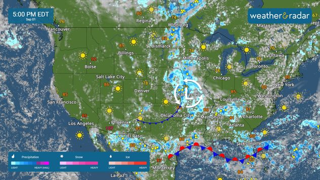
The WeatherRadar shows storms forming along a stationary front draped across the south and along a system tracking from the Plains into the upper Mississippi River Valley.

Some isolated flash flooding will be possible in cities like El Paso, Texas, New Orleans, Mobile, Ala., and Tallahassee, Fla. Stay alert, especially if you plan to travel along I-10.

Cooler-than-average temperatures continue today across much of the country, with a few exceptions. Warmer-than-average highs are expected in the Pacific Northwest and across much of the West Coast.

The TemperatureRadar shows highs in the 100s across the Southwest, including in Phoenix, while Boise, Idaho, sees the mid-90s. A taste of autumn lingers across the eastern two-thirds, with cooler-than-average highs sticking around in cities like Atlanta, Houston and New York.

Tropical Update

A tropical wave emerging off the coast of Africa may see some development in the coming days. We'll keep a close eye on the Atlantic Basin.

App News

The Atlantic Hurricane Season peaks in September, and you will want to be ready. Learn more about how our hurricane alerts work here.

Mary Mays
More on the topic
Hurricane parade in the Pacific. Karina is very strong. . Weather Videos. Tuesday, September 1, 2026
WindRadar for Friday, showing the three hurricanes – Lowell, Karina and Maria – over the Pacific.
Weather VideosTuesday, September 1, 2026

Karina is very strong

Hurricane parade in the Pacific
How does fog form?. Multiple ways. . . Saturday, September 12, 2026
Saturday, September 12, 2026

Multiple ways

How does fog form?
Hurricane Polo remains dangerous. Active Pacific. . . Thursday, September 24, 2026
Thursday, September 24, 2026

Active Pacific

Hurricane Polo remains dangerous
All weather news
This might also interest you
Isaias post-landfall impacts. Southeast soaker. . . Saturday, October 10, 2026
Southeast impacts of Isaias
Saturday, October 10, 2026

Southeast soaker

Isaias post-landfall impacts
Moisture from Simon supercharges rain. Central US. . . Wednesday, October 14, 2026
Tropical moisture from Pacific Hurricane Simon is supercharging rainfall totals across portions of the central and southern Plains. Record-high moisture levels are being observed due to this setup.
Wednesday, October 14, 2026

Central US

Moisture from Simon supercharges rain
Soggy end to the weekend for some. Remnants of Isaias. . . Sunday, October 11, 2026
While Isaias may have made landfall near Destin, Fla., Friday night, the hurricane's remnants will bring a soggy end to the weekend hundreds of miles away from the point of landfall.
Sunday, October 11, 2026

Remnants of Isaias

Soggy end to the weekend for some
All articles
Weather & Radar

Weather & Radar is also available on

Google Play StoreApp Store

Company

Contact us Privacy policy Legal info Accessibility statement

Services

Uploader

Socials

instagramfacebookthreadslinkList