Home
Weather New York
WeatherRadar
RainRadar
TemperatureRadar
WindRadar
LightningRadar
Weather News
Editor's Pick
Discover the app
Weather widget
Contact us
Apps
Career
    Home / Weather News /

    Daily briefing: More summer storm trouble

12:45 PM
June 27, 2025

Daily briefing
More summer storm trouble

The work week ends with typical summer weather across the U.S. This means a mix of big thunderstorms, hot weather and sunburn inducing sunshine found nationally. The Weather & Radar daily briefing is published every weekday at 5 a.m. ET with the latest U.S. forecast and updated tropical information.

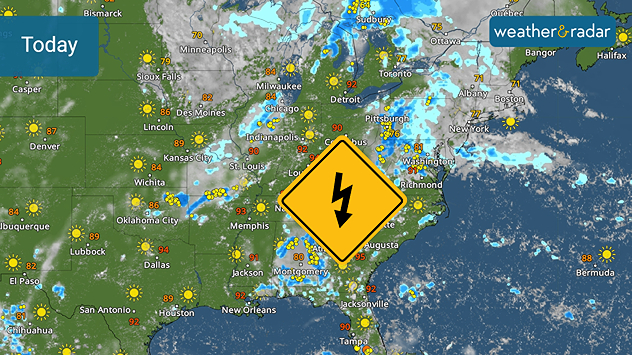
Friday will be a near repeat of Thursday across the U.S. The WeatherRadar shows strong storms developing this afternoon across Florida, the Mid-Atlantic and a in a corridor running from western Texas northeastward into the western Great Lakes.

Thunderstorms likely across the East
Thunderstorms threatens the East Coast.

The South and Southeast could see a few widely-scattered storms as early sunshine sends temperatures into the upper 80s and low 90s in most places. The TemperatureRadar is a great tool for checking the temperatures readings today.

Looking to the West, a quiet Friday is on tap for most places. There will be a few clouds in the Northwest and along the immediate coast, suppressing today's highs. The interior West will be in the 90s and 100s in the Southwest while 80s are common.

Tropical Update

The Atlantic Hurricane basin is quiet and will remain so through the rest of the week. In the eastern Pacific, forecasters are still watching for possible development well off Central America's coast. This system could move to the northwest and develop into the next tropical system today or Friday. It will remain offshore for the next several days.

News we are covering

  • Major heat wave continues
  • Lightning safety

In case you missed

Group of 20 hit by lightningread more

App news

Our hurricane alerts can help keep you prepared this hurricane season. Ensure you have downloaded the Weather & Radar app's latest version and turn on your alerts. Learn more here.

James West
More on the topic
Hawaii's second 2026 hurricane impact. Hurricane Lowell. . . Tuesday, September 8, 2026
Tuesday, September 8, 2026

Hurricane Lowell

Hawaii's second 2026 hurricane impact
How does fog form?. Multiple ways. . . Saturday, September 12, 2026
Saturday, September 12, 2026

Multiple ways

How does fog form?
Hurricane Polo remains dangerous. Active Pacific. . . Thursday, September 24, 2026
Thursday, September 24, 2026

Active Pacific

Hurricane Polo remains dangerous
All weather news
This might also interest you
Useful tips when driving in the rain. Flood safety. . . Saturday, October 3, 2026
Saturday, October 3, 2026

Flood safety

Useful tips when driving in the rain
First hurricane of the Atlantic season. Isaias forms. . . Thursday, October 8, 2026
After a quiet start, the Atlantic's first hurricane has finally formed. Isaias is the latest first hurricane since the satellite era began in1966. With the Gulf Coast in sight, what impacts are expected?
Thursday, October 8, 2026

Isaias forms

First hurricane of the Atlantic season
40-degree difference over 101 miles. Eureka to Redding. . . Tuesday, October 6, 2026
Tuesday, October 6, 2026

Eureka to Redding

40-degree difference over 101 miles
All articles
Weather & Radar

Weather & Radar is also available on

Google Play StoreApp Store

Company

Contact us Privacy policy Legal info Accessibility statement

Services

Uploader

Socials

instagramfacebookthreadslinkList