Home
Weather New York
WeatherRadar
RainRadar
TemperatureRadar
WindRadar
LightningRadar
Weather News
Editor's Pick
Discover the app
Weather widget
Contact us
Apps
Career
    Home / Weather News /

    Dangerous wind chills too: Extreme cold hits East

11:00 AM
February 7, 2026

Dangerous wind chills
Extreme cold hits East

A major arctic front that swept through early this morning will usher in an extremely cold and blustery day throughout the Northeast and Mid-Atlantic. This combination will produce dangerous wind chills.

The WindRadar animation above shows the high winds arriving early this morning and lasting through tonight and lingering into Sunday. Wind gusts as high as 50 mph could cause sporadic power outages and make driving high-profile vehicles difficult.

A frigid Saturday ahead

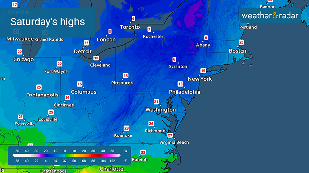
Arctic air will accompany the high winds. The TemperatureRadar shows today's highs will only be in the single digits across the Northeast, with the Mid-Atlantic and upper Ohio Valley will only be in the teens and low 20s.

The combination of high winds and temperatures will cause dangerous wind chills and the feel-like temperatures will be well below zero. Outdoor activities should be limited and if you must be outside, wear several layers of warm clothing and make sure all parts of the body are covered.

James West
More on the topic
Europe: Warmest June on record. Warm waters too. . . Friday, July 10, 2026
The record-breaking heatwave in June has made climate history in Western Europe.
Friday, July 10, 2026

Warm waters too

Europe: Warmest June on record
Record-breaking heatwave in Europe. Hotter than most of U.S.. . . Thursday, June 25, 2026
Thursday, June 25, 2026

Hotter than most of U.S.

Record-breaking heatwave in Europe
Super Typhoon Bavi threatens Taiwan. 155 mph winds. . Weather Videos. Wednesday, July 8, 2026
The image shows an intense tropical cyclone over the western Pacific, east of Taiwan and the Philippines. The centre of the system is depicted as a light purple and white vortex with a clearly visible eye, surrounded by a ring of red and orange areas indicating the strongest wind speeds. A white arrow marks the typhoon’s predicted track towards the north-west, in the direction of Taiwan. To the west of the storm lie the Philippines, with the cities of Manila and Cebu; to the north of these lies Taiwan, with Taipei. Further west, the Chinese coast, including Hong Kong, and parts of Vietnam can be seen. The coloured wind map shows predominantly green areas outside the storm’s core, indicating significantly weaker winds. White streamlines illustrate the typhoon’s anti-clockwise circulation in the Northern Hemisphere. The highest wind speeds are concentrated around the eye of the cyclone.
Weather VideosWednesday, July 8, 2026

155 mph winds

Super Typhoon Bavi threatens Taiwan
All weather news
This might also interest you
6 easy steps to take now to be ready. Hurricane preparedness. . . Sunday, August 9, 2026
Are you ready?
Sunday, August 9, 2026

Hurricane preparedness

6 easy steps to take now to be ready
Big 50-degree jump. Northwest heat extremes. . . Thursday, August 6, 2026
Big temperature jumps
Thursday, August 6, 2026

Northwest heat extremes

Big 50-degree jump
Be ready for tropical activity. Tips & tools. . . Saturday, August 8, 2026
Track hurricanes with the WeatherRadar
Saturday, August 8, 2026

Tips & tools

Be ready for tropical activity
All articles
Weather & Radar

Weather & Radar is also available on

Google Play StoreApp Store

Company

Contact us Privacy policy Legal info Accessibility statement

Services

Uploader

Socials

instagramfacebookthreadslinkList