Home
Weather New York
WeatherRadar
RainRadar
TemperatureRadar
WindRadar
LightningRadar
Weather News
Editor's Pick
Discover the app
Weather widget
Contact us
Apps
Career
    Home / Editor's Pick /

    Deep South thru Texas: Rounds of severe storms threaten

02:14 PM
March 25, 2024

Deep South thru Texas
Rounds of severe storms threaten

We start the week with the threat of severe storms affecting much of the Deep South through Houston, Texas. The main threats will be tornadoes, damaging winds, and hail. Let’s look at the timing.

Two low-pressure systems are traveling across the mid-region of the U.S. over the surface. One is heading toward the Great Lakes Area and another one will dig a bit more south and ahead of the previously mentioned low, over Arkansas. Both systems drag their respective cold front. Injecting more energy is a low-pressure system in the upper levels of the atmosphere which will be the main driving for the setup on the surface to turn severe in the afternoon and evening hours.

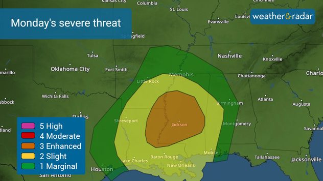
Monday's severe weather threat. Level 3 out of 5 over the Deep South.

Ahead of the cold fronts, plenty of warm air comes in from the Gulf of Mexico, which will set up camp over eastern Texas, Louisiana, Arkansas, Mississippi, and Alabama. This is where the risk for severe storms will be, with the severity level at a 3 out of 5 and 2 out of 5 for much of this area. East Texas is at a level 1 out of 5, with the chance of a few isolated severe storms moving over during the afternoon. By the evening hours, storms will ramp up in intensity and become better organized as they move eastward over the Deep South.

By Tuesday afternoon and evening, the chance for severe storms will be split into two areas. One over the southern Great Lakes and another one over southern Alabama and the Florida Panhandle. The storm systems will continue to lose their punch, but there could be some storms that could still bring damaging winds and we cannot rule out a tornado.

Guide to turn on your weather alertsread more

Please make sure to have at least 3 ways of receiving weather alerts and track the storms in our WeatherRadar. Remember that a severe thunderstorm warning or tornado warning is issued for your location because a severe storm or tornado has been detected and you should take shelter immediately. Our team of meteorologists will be tracking these systems and will continue to keep you updated throughout the day in our app and across our social media platforms.

**You can find this article in Spanish too. Make sure to share it with your friends and family to stay informed and safe**

Irene Sans
More on the topic
High pressure & extreme heat. Why & how does it work?. . . Sunday, July 12, 2026
Sunday, July 12, 2026

Why & how does it work?

High pressure & extreme heat
Record-breaking heatwave in Europe. Hotter than most of U.S.. . . Thursday, June 25, 2026
Thursday, June 25, 2026

Hotter than most of U.S.

Record-breaking heatwave in Europe
How does fog form?. Multiple ways. . . Saturday, July 11, 2026
Saturday, July 11, 2026

Multiple ways

How does fog form?
All weather news
This might also interest you
Heat indices soaring. High humidity. . . Saturday, July 25, 2026
Saturday, July 25, 2026

High humidity

Heat indices soaring
When severe storms strike.... You can be ready. . . Sunday, July 26, 2026
Sunday, July 26, 2026

You can be ready

When severe storms strike...
How does a hurricane form?. Hurricane preparedness. . . Sunday, July 19, 2026
hurricane maria
Sunday, July 19, 2026

Hurricane preparedness

How does a hurricane form?
All articles
Weather & Radar

Weather & Radar is also available on

Google Play StoreApp Store

Company

Contact us Privacy policy Legal info Accessibility statement

Services

Uploader

Socials

instagramfacebookthreadslinkList