Home
Weather New York
WeatherRadar
RainRadar
TemperatureRadar
WindRadar
LightningRadar
Weather News
Editor's Pick
Discover the app
Weather widget
Contact us
Apps
Career
    Home / Weather News /

    Flood safety - Useful tips when driving in the rain

07:00 PM
August 30, 2025

Flood safety
Useful tips when driving in the rain

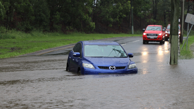
Areas that experience slow-moving storms or back-to-back downpours could see localized flash flooding.

Although driving in flooded areas and heavy rain is best avoided, it is essential to stay safe if you absolutely need to travel. Continue reading below for tips on how to drive carefully in heavy rain and flooding.

Before you start driving, check where the flood warnings are and view the WeatherRadar for your area. Try to avoid these routes where flood warnings are issued or are experiencing heavy rain. Secondly, you should check your windscreen and rear-view wipers. Make sure they are working well, as you will be relying on them for visibility.

When driving, have your lights on; this will increase visibility for you and those around you. It is also essential to leave a more significant gap between you and other cars as your stopping distance will be greater. Never drive fast to risk skidding or hydroplaning.

Lastly, never drive across a flooded area. Water often prevents the driver from adequately estimating the water's depth or knowing if the road has collapsed beneath. It takes just 12 inches of rushing water to carry away most cars, and only 2 feet of flowing water can carry away SUVs and trucks.

Mary Mays
More on the topic
Super Typhoon Bavi threatens Taiwan. 155 mph winds. . Weather Videos. Wednesday, July 8, 2026
The image shows an intense tropical cyclone over the western Pacific, east of Taiwan and the Philippines. The centre of the system is depicted as a light purple and white vortex with a clearly visible eye, surrounded by a ring of red and orange areas indicating the strongest wind speeds. A white arrow marks the typhoon’s predicted track towards the north-west, in the direction of Taiwan. To the west of the storm lie the Philippines, with the cities of Manila and Cebu; to the north of these lies Taiwan, with Taipei. Further west, the Chinese coast, including Hong Kong, and parts of Vietnam can be seen. The coloured wind map shows predominantly green areas outside the storm’s core, indicating significantly weaker winds. White streamlines illustrate the typhoon’s anti-clockwise circulation in the Northern Hemisphere. The highest wind speeds are concentrated around the eye of the cyclone.
Weather VideosWednesday, July 8, 2026

155 mph winds

Super Typhoon Bavi threatens Taiwan
Rip currents & safety tips. As more head to the coast. . . Saturday, July 25, 2026
rip current
Saturday, July 25, 2026

As more head to the coast

Rip currents & safety tips
How does fog form?. Multiple ways. . . Saturday, July 11, 2026
Saturday, July 11, 2026

Multiple ways

How does fog form?
All weather news
This might also interest you
Dust Bowl period record could fall. North Texas. . . Tuesday, August 25, 2026
Tuesday, August 25, 2026

North Texas

Dust Bowl period record could fall
Understanding the feels like temperature. Advanced heat measurement. . . Sunday, August 30, 2026
feels like temperature
Sunday, August 30, 2026

Advanced heat measurement

Understanding the feels like temperature
Useful tips when driving in the rain. Flood safety. . . Sunday, August 30, 2026
Sunday, August 30, 2026

Flood safety

Useful tips when driving in the rain
All articles
Weather & Radar

Weather & Radar is also available on

Google Play StoreApp Store

Company

Contact us Privacy policy Legal info Accessibility statement

Services

Uploader

Socials

instagramfacebookthreadslinkList