Home
Weather New York
WeatherRadar
RainRadar
TemperatureRadar
WindRadar
LightningRadar
Weather News
Editor's Pick
Discover the app
Weather widget
Contact us
Apps
Career
    Home / Weather News /

    Flood threat targets South

01:54 PM
May 26, 2026

Downpours continue
Flood threat targets South

Rain soaked much of the South over the holiday weekend, and the unsettled weather continues through the rest of the week. Flash flooding is a concern as heavy rain falls in already saturated areas.

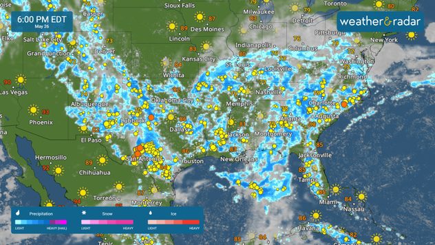
After a rain-soaked weekend, where more than 6 inches of rain fell across parts of Texas and the Southeast, more rain is in the forecast. Flash flooding is a concern for much of this region through the remainder of the week.

The WeatherRadar shows showers and storms firing up across Texas and the Southeast today. Cities at risk of flash flooding include Dallas, Austin, and San Antonio, Texas, as well as New Orleans, Montgomery, Ala., Atlanta, Charlotte, N.C., and Roanoke, Va.

Flash flooding will be possible across portions of Texas and into the Southeast.

More rain is anticipated tomorrow, with cities such as Houston and Shreveport, La., at risk of flooding. The threat of flash flooding also extends into the Appalachians and the Ohio Valley tomorrow, with Cincinnati and Charleston, W.V., at risk.

Rain will continue to bring renewed flood threats across the Gulf Coast and South on Thursday and Friday. Stay alert and make sure your Weather & Radar app alerts are turned on.

Mary Mays
More on the topic
Super Typhoon Bavi threatens Taiwan. 155 mph winds. . Weather Videos. Wednesday, July 8, 2026
The image shows an intense tropical cyclone over the western Pacific, east of Taiwan and the Philippines. The centre of the system is depicted as a light purple and white vortex with a clearly visible eye, surrounded by a ring of red and orange areas indicating the strongest wind speeds. A white arrow marks the typhoon’s predicted track towards the north-west, in the direction of Taiwan. To the west of the storm lie the Philippines, with the cities of Manila and Cebu; to the north of these lies Taiwan, with Taipei. Further west, the Chinese coast, including Hong Kong, and parts of Vietnam can be seen. The coloured wind map shows predominantly green areas outside the storm’s core, indicating significantly weaker winds. White streamlines illustrate the typhoon’s anti-clockwise circulation in the Northern Hemisphere. The highest wind speeds are concentrated around the eye of the cyclone.
Weather VideosWednesday, July 8, 2026

155 mph winds

Super Typhoon Bavi threatens Taiwan
How does fog form?. Multiple ways. . . Saturday, July 11, 2026
Saturday, July 11, 2026

Multiple ways

How does fog form?
What are weather fronts?. Weather explained. . . Sunday, August 23, 2026
Image of a temperature radar showing a clear distinction between a warm and cold air mass separated by a cold front.
Sunday, August 23, 2026

Weather explained

What are weather fronts?
All weather news
This might also interest you
Tornado producer brings fall refresh. Northeast low. . . Friday, August 21, 2026
Friday, August 21, 2026

Northeast low

Tornado producer brings fall refresh
Temperatures rise 20 degrees at 2 am?. What is a heat burst?. . . Sunday, August 16, 2026
Heat burst in Nebraska
Sunday, August 16, 2026

What is a heat burst?

Temperatures rise 20 degrees at 2 am?
Days of record nighttime heat. Feeling tropical. . . Monday, August 17, 2026
Monday, August 17, 2026

Feeling tropical

Days of record nighttime heat
All articles
Weather & Radar

Weather & Radar is also available on

Google Play StoreApp Store

Company

Contact us Privacy policy Legal info Accessibility statement

Services

Uploader

Socials

instagramfacebookthreadslinkList