Home
Weather New York
WeatherRadar
RainRadar
TemperatureRadar
WindRadar
LightningRadar
Weather News
Editor's Pick
Discover the app
Weather widget
Contact us
Apps
Career
    Home / Editor's Pick /

    Florida flood risk ending? Up to 4 inches could fall Friday

02:31 PM
June 14, 2024

Florida flood risk ends?
Up to 4 inches could fall Friday

A stream of moisture will continue to camp over South Florida, bringing in a few more rounds of storms on Friday and Saturday. When will it end?

Some heavy showers moved through Broward County around sunrise. There is a break from the heaviest downpours but expect the atmosphere to become more unstable by the afternoon and storms to ignite again through the early evening.

The weekend starts with the tail end of the stream of moisture that will bring higher-than-normal storm coverage (yes, we are in the rainy season). The winds will also shift this weekend which will allow the storms to change location and affect inland locations more prominently on Sunday. For Friday and Saturday, storms are fair game across all areas of South Florida, but the heaviest and strongest will be over Monroe and Miami-Dade counties.

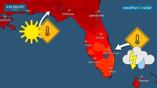
South Florida will stay cooler than the northern half sur to the clouds and showers on Saturday.
South Florida will stay cooler than the northern half due to the clouds and showers on Saturday.

Flooding is still possible with super-saturated grounds at play

Some storms could bring higher rainfall rates than others. Overall, we are forecasting between 2 and 4 inches of rain on Friday, mainly from southern Broward southward into the Miami area. On Saturday the storms could also bring a couple of inches of rainfall, but they will be more isolated. Please stay off flooded roads and don’t try to cross if you encounter floodwater, it could be deeper than expected.

Irene Sans
More on the topic
How does fog form?. Multiple ways. . . Saturday, September 12, 2026
Saturday, September 12, 2026

Multiple ways

How does fog form?
Hurricane Polo remains dangerous. Active Pacific. . . Thursday, September 24, 2026
Thursday, September 24, 2026

Active Pacific

Hurricane Polo remains dangerous
Hurricane parade in the Pacific. Karina is very strong. . Weather Videos. Tuesday, September 1, 2026
WindRadar for Friday, showing the three hurricanes – Lowell, Karina and Maria – over the Pacific.
Weather VideosTuesday, September 1, 2026

Karina is very strong

Hurricane parade in the Pacific
All weather news
This might also interest you
More signs of autumn. Cooler days ahead. . . Friday, September 18, 2026
Friday, September 18, 2026

Cooler days ahead

More signs of autumn
Hawaii's busy hurricane season. Nolo could set record. . . Thursday, September 24, 2026
Hawaii troubles
Thursday, September 24, 2026

Nolo could set record

Hawaii's busy hurricane season
30-degree drop on heels of equinox. Mid-Atlantic & Southeast. . . Monday, September 21, 2026
Monday, September 21, 2026

Mid-Atlantic & Southeast

30-degree drop on heels of equinox
All articles
Weather & Radar

Weather & Radar is also available on

Google Play StoreApp Store

Company

Contact us Privacy policy Legal info Accessibility statement

Services

Uploader

Socials

instagramfacebookthreadslinkList