Home
Weather New York
WeatherRadar
RainRadar
TemperatureRadar
WindRadar
LightningRadar
Weather News
Editor's Pick
Discover the app
Weather widget
Contact us
Apps
Career
    Home / Editor's Pick /

    Friday's live blog: Travel nightmare, major roads closed

10:05 PM
March 1, 2024

Friday's live blog
Travel nightmare, major roads closed

Recommended external content from YouTube

We need your consent to show content from YouTube. You can withdraw your consent at any time.

I agree that content from YouTube will be displayed to me.
Privacy policy

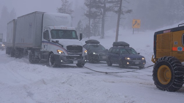
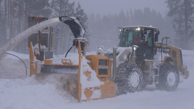
A massive storm will likely bring historic snowfall over the Sierra Nevada mountains. Some areas are forecast to receive close to 12 feet of snow, while lower elevations will be dealing with rain which may lead to flooding. Another big impact will be the winds. Gusts could approach 140 mph along the higher peaks, and 70 mph across lower elevations. Power outages are possible. Traveling is not recommended as conditions will be dangerous and life-threatening.

6:00 p.m. ET/3:00 p.m. PT

Wind gusts in excess of 100 mph have been recorded along ridgetops in the Sierra Nevada. As heavy snow and wind continues, travel will be dangerous and power outages will be possible.

5:00 p.m. ET/2:00 p.m. PT

Worsening weather through the rest of Friday into Saturday. Sierra
Worsening weather through the rest of Friday into Saturday.
sierra snowstorm
Worsening weather through the rest of Friday into Saturday. Sierra
1/5

4:30 p.m. ET/1:30 p.m. PT

Our weather reporter, Jonathan Petramala, is reporting from Donner Pass, California, and will continue to follow this storm closely through the weekend. Check out his latest report.

3:30 p.m. ET/12:30 p.m. PT

The system affecting the West will continue to pound the Sierras. On top of the almost 2 feet that fell overnight across some areas, there could be another 5-6 feet falling through Saturday afternoon. Another 2-4 feet could accumulate on Sunday and Monday.

It is important to point out that snowfall will start to happen across lower elevations at around 1,000 to 1,500 feet this Friday or Saturday early. Some locals say that this storm is unique as 12 feet of snow from just one system is a lot.

Local residents can expect power outages through the weekend.

2:45 p.m. ET/11:45 a.m. PT

1:40 p.m. ET/10:40 a.m. PT

Meteorologist Becca Parker will be live at 3 p.m. ET / 12 p.m. PT to discuss the worsening weather conditions expected for the California mountains on Friday and Saturday.

Watch her live, set your alarms.

12:40 p.m. ET/9:40 a.m. PT

Snowpack continues to grow!

11:40 a.m. ET/8:40 a.m. PT

Heavy snow has been falling overnight on the Sierras. This storm will bring a multi-day risk for blizzards, which will cause whiteout conditions along the mountains, even across elevations of 2000 feet. This will not the right weekend to travel to or from the mountains.

Across the backcountry over the central Sierra, there is a high to extreme risk of avalanches.

Irene Sans
Weather & Radar USA editorial team
More on the topic
Record ocean heat halting hurricanes. Strong El Niño influence. . . Sunday, September 13, 2026
A weather map shows a calm Atlantic Ocean with no hurricanes, alongside a picture of the sea.
Sunday, September 13, 2026

Strong El Niño influence

Record ocean heat halting hurricanes
Hurricane Polo remains dangerous. Active Pacific. . . Thursday, September 24, 2026
Thursday, September 24, 2026

Active Pacific

Hurricane Polo remains dangerous
How does fog form?. Multiple ways. . . Saturday, September 12, 2026
Saturday, September 12, 2026

Multiple ways

How does fog form?
All weather news
This might also interest you
October's rain doubled in just days. Flooding possible. . . Tuesday, October 13, 2026
Tuesday, October 13, 2026

Flooding possible

October's rain doubled in just days
Soggy end to the weekend for some. Remnants of Isaias. . . Sunday, October 11, 2026
While Isaias may have made landfall near Destin, Fla., Friday night, the hurricane's remnants will bring a soggy end to the weekend hundreds of miles away from the point of landfall.
Sunday, October 11, 2026

Remnants of Isaias

Soggy end to the weekend for some
145-year-old record could be tied. Late-season heatwave. . . Wednesday, October 14, 2026
Wednesday, October 14, 2026

Late-season heatwave

145-year-old record could be tied
All articles
Weather & Radar

Weather & Radar is also available on

Google Play StoreApp Store

Company

Contact us Privacy policy Legal info Accessibility statement

Services

Uploader

Socials

instagramfacebookthreadslinkList