Home
Weather New York
WeatherRadar
RainRadar
TemperatureRadar
WindRadar
LightningRadar
Weather News
Editor's Pick
Discover the app
Weather widget
Contact us
Apps
Career
    Home / Weather News /

    Heat wave for the West: More than 50 million under heat alerts

04:27 PM
July 1, 2024

Heat wave for the West
More than 50 million under heat alerts

More than 50 million are under heat alerts from the West Coast to the Southeast.

It's the first day of July and dangerous heat is already building in across the West Coast, central and southern Plains, and across the Southeast. The upper-level pattern shows two ridges building, including one off the West Coast and another over the lower Mississippi Valley. These ridges will help send temperatures climbing well above average and even into record territory.

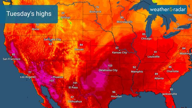
Tuesday's highs

The central U.S. will see highs reaching the 90s and 100s today and in the coming days. Cities such as Dallas, Wichita, Kan., and Oklahoma City will see highs near or above 100 degrees. With lows staying in the 70s and 80s, it will be difficult to cool down. In the Southeast and along the Gulf Coast, humidity will send "feels like" temperatures into the triple digits. There will be little relief from the heat this week in these regions.

Extreme heat will also begin building along the West Coast tomorrow. While the immediate coast will stay cooler, interior communities in California will range from 100 to 110 degrees. New record highs are possible across the San Joaquin and Sacramento valleys on Tuesday and Wednesday. This heat will continue into the Fourth of July holiday on Thursday and through the remainder of the week.

With dangerous heat in the forecast, it's important to stay hydrated, wear loose and light colored clothing and check conditions on the TemperatureRadar before heading outdoors.

More on the topic

Hurricane Polo remains dangerous. Active Pacific. . . Thursday, September 24, 2026
Thursday, September 24, 2026

Active Pacific

Hurricane Polo remains dangerous
Record ocean heat halting hurricanes. Strong El Niño influence. . . Sunday, September 13, 2026
A weather map shows a calm Atlantic Ocean with no hurricanes, alongside a picture of the sea.
Sunday, September 13, 2026

Strong El Niño influence

Record ocean heat halting hurricanes
How does fog form?. Multiple ways. . . Saturday, September 12, 2026
Saturday, September 12, 2026

Multiple ways

How does fog form?
All weather news

This might also interest you

Below-average activity continues. Quiet Atlantic. . . Monday, October 19, 2026
Monday, October 19, 2026

Quiet Atlantic

Below-average activity continues
October's rain doubled in just days. Flooding possible. . . Tuesday, October 13, 2026
Tuesday, October 13, 2026

Flooding possible

October's rain doubled in just days
Fall fronts bring big changes. How to track them. . . Friday, October 16, 2026
Friday, October 16, 2026

How to track them

Fall fronts bring big changes
All articles
Weather & Radar

Weather & Radar is also available on

Google Play StoreApp Store

Company

Contact us Privacy policy Legal info Accessibility statement

Services

Uploader

Socials

instagramfacebookthreadslinkList