Home
Weather New York
WeatherRadar
RainRadar
TemperatureRadar
WindRadar
LightningRadar
Weather News
Editor's Pick
Discover the app
Weather widget
Contact us
Apps
Career
    Home / Editor's Pick /

    Heavenly rendezvous – planetary encounter in the morning sky

07:00 PM
August 9, 2025

Heavenly rendezvous
Planet meeting in the morning sky

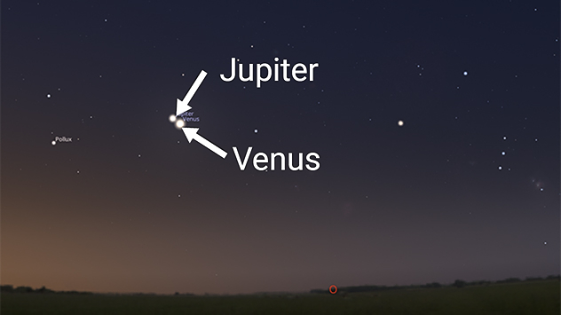
Night sky with Venus and Jupiter close together, clearly labelled; beneath the starry sky, the flat silhouette of a landscape can be seen.

Starting on Sunday, you can admire a cosmic highlight: a fascinating planetary encounter in the morning sky. Venus, the bright morning "star", will pass close to Jupiter, the second brightest planet.

Our neighboring planet will reach its closest point on the morning of August 12th. From about 5 a.m., the elusive Mercury will even join it directly above the horizon.

The video shows the daily change in the positions of Venus and Jupiter until August 20th, when even the narrow crescent moon passes between the two bright planets, forming a spectacular trio of celestial bodies.

To see if and where the weather will cooperate, it's best to keep an eye on the current WeatherRadar.

Did you know?

Mid-August is also the time of the Perseids. This year, however, the shooting stars may not be very noticeable due to the bright full moon.

James West
More on the topic
Super Typhoon Bavi threatens Taiwan. 155 mph winds. . Weather Videos. Wednesday, July 8, 2026
The image shows an intense tropical cyclone over the western Pacific, east of Taiwan and the Philippines. The centre of the system is depicted as a light purple and white vortex with a clearly visible eye, surrounded by a ring of red and orange areas indicating the strongest wind speeds. A white arrow marks the typhoon’s predicted track towards the north-west, in the direction of Taiwan. To the west of the storm lie the Philippines, with the cities of Manila and Cebu; to the north of these lies Taiwan, with Taipei. Further west, the Chinese coast, including Hong Kong, and parts of Vietnam can be seen. The coloured wind map shows predominantly green areas outside the storm’s core, indicating significantly weaker winds. White streamlines illustrate the typhoon’s anti-clockwise circulation in the Northern Hemisphere. The highest wind speeds are concentrated around the eye of the cyclone.
Weather VideosWednesday, July 8, 2026

155 mph winds

Super Typhoon Bavi threatens Taiwan
How does fog form?. Multiple ways. . . Saturday, July 11, 2026
Saturday, July 11, 2026

Multiple ways

How does fog form?
Record-breaking heatwave in Europe. Hotter than most of U.S.. . . Thursday, June 25, 2026
Thursday, June 25, 2026

Hotter than most of U.S.

Record-breaking heatwave in Europe
All weather news
This might also interest you
Days of record nighttime heat. Feeling tropical. . . Monday, August 17, 2026
Monday, August 17, 2026

Feeling tropical

Days of record nighttime heat
Downbursts: Why are they dangerous?. Torrential downpour. . . Saturday, August 15, 2026
Downburst shown on the WeatherRadar.
Saturday, August 15, 2026

Torrential downpour

Downbursts: Why are they dangerous?
Understanding the feels like temperature. Advanced heat measurement. . . Saturday, August 15, 2026
feels like temperature
Saturday, August 15, 2026

Advanced heat measurement

Understanding the feels like temperature
All articles
Weather & Radar

Weather & Radar is also available on

Google Play StoreApp Store

Company

Contact us Privacy policy Legal info Accessibility statement

Services

Uploader

Socials

instagramfacebookthreadslinkList