Home
Weather New York
WeatherRadar
RainRadar
TemperatureRadar
WindRadar
LightningRadar
Weather News
Editor's Pick
Discover the app
Weather widget
Contact us
Apps
Career
    Home / Weather News /

    Hurricane Melissa rapidly intensifies, catastrophic impacts

05:10 PM
October 26, 2025

Jamaica, Cuba in path
Hurricane Melissa rapidly intensifies, catastrophic impacts

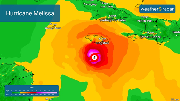
In just over 36 hours, Major Hurricane Melissa has strengthened from a tropical storm to a top of the scale Category 5 hurricane. This potent, slow-moving hurricane will roll across Jamaica on Tuesday before slamming into eastern Cuba on Wednesday.

Melissa is third Category 5 of 2025

Erin and Humberto were also Category 5 hurricanes this year. The record year for Category 5 hurricanes is 2005 when Emily, Katrina, Rita and Wilma were all Category 5 storms.  

Monday morning satellite images show shows a intense eye, indicating the hurricane's ferocity. Tropical storm–force winds are already buffeting Jamaica as wind speeds increase across the Caribbean island. Melissa is expected to fluctuate between Categories 4 and 5 over the next 24 to 36 hours as it nears Jamaica.

The hurricane will likely strike Jamaica as a powerful Category 4 or 5 storm, then move over eastern Cuba as a major hurricane Tuesday night into Wednesday morning. Once it turns north-northeast, Melissa will accelerate, crossing the southern Bahamas and the Turks and Caicos Islands.

Expected Impacts

The central Caribbean has already faced heavy rain, flooding, and landslides. Eastern Jamaica, which could see more than 40 inches of rain, faces catastrophic flooding, landslides, and violent winds through Monday. Storm surge in excess of 10 feet above normal water levels are likely along Jamaica's southern coast tonight through Tuesday.

Haiti continues to endure life-threatening flash floods, while Cuba, the southern Bahamas, and the Turks and Caicos should prepare for storm surge, destructive winds, and 6–12 inches of rain through Wednesday. These rainfall forecasts are in addition to the amounts received this past week.

Irene Sans
More on the topic
Waterspouts possible, what are they?. They can be dangerous. . . Sunday, August 9, 2026
Waterspouts weatherradar.
Sunday, August 9, 2026

They can be dangerous

Waterspouts possible, what are they?
All about nocturnal severe weather. Risks & preparedness. . . Saturday, August 22, 2026
Saturday, August 22, 2026

Risks & preparedness

All about nocturnal severe weather
Rip currents & safety tips. As more head to the coast. . . Saturday, July 25, 2026
rip current
Saturday, July 25, 2026

As more head to the coast

Rip currents & safety tips
All weather news
This might also interest you
Temperatures rise 20 degrees at 2 am?. What is a heat burst?. . . Sunday, August 16, 2026
Heat burst in Nebraska
Sunday, August 16, 2026

What is a heat burst?

Temperatures rise 20 degrees at 2 am?
What to know this hurricane season. Knowledge is power. . . Sunday, August 23, 2026
Hurricanes approaching the coastline can cause extensive impacts, including flooding, even before landfall.
Sunday, August 23, 2026

Knowledge is power

What to know this hurricane season
Gravity wave clouds explained. The ideal conditions. . . Saturday, August 22, 2026
Saturday, August 22, 2026

The ideal conditions

Gravity wave clouds explained
All articles
Weather & Radar

Weather & Radar is also available on

Google Play StoreApp Store

Company

Contact us Privacy policy Legal info Accessibility statement

Services

Uploader

Socials

instagramfacebookthreadslinkList