Home
Weather New York
WeatherRadar
RainRadar
TemperatureRadar
WindRadar
LightningRadar
Weather News
Editor's Pick
Discover the app
Weather widget
Contact us
Apps
Career
    Home / Weather News /

    Latest hurricane update: Erin to slide by Hatteras

04:53 PM
August 19, 2025

Latest hurricane update
Erin to slide by Hatteras

Hurricane Erin continues to churn over the Atlantic. Although a direct hit to the U.S. is not likely, its effects will be felt along the East Coast.

North Carolina’s Outer Banks will feel its effects over the next 72 hours. High winds gusting to tropical storm strength -- 39 mph to 73 mph -- will be accompanied by squalls of downpours.

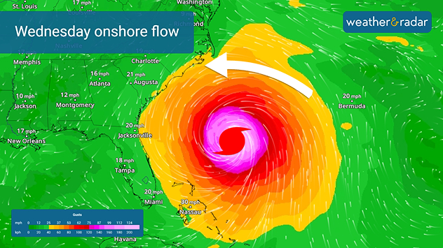
Erin's Onshore flow
Although a direct hit isn't in the forecast, onshore winds will bring a storm surge to the Carolinas.

The WindRadar shows onshore flow, which will produce upwards of 4 feet of surge throughout the Outer Banks. Pounding waves will ride atop the surge. Coastal flooding and beach erosion are likely.

The National Hurricane Center has issued a Tropical Storm Warning for the North Carolina coasts and evacuations were ordered Monday in anticipation of Erin’s offshore passage.

The WeatherRadar shows Hurricane Erin curving to the northeast away from the East Coast after it makes its closes approach with Cape Hatteras late Wednesday night. As it moves into the open Atlantic, it will produce rip currents and high surf throughout the Atlantic Seaboard.

The Atlantic Hurricane Season is entering its peak time and now is the time for people to prepare for the season ahead.

James West
More on the topic
How does fog form?. Multiple ways. . . Saturday, July 11, 2026
Saturday, July 11, 2026

Multiple ways

How does fog form?
Rip currents & safety tips. As more head to the coast. . . Saturday, July 25, 2026
rip current
Saturday, July 25, 2026

As more head to the coast

Rip currents & safety tips
The best views of Wednesday's eclipse. Europe's sky show. . . Thursday, August 13, 2026
Solar eclipse: The sun obscured between wind turbines in Sardinia
Thursday, August 13, 2026

Europe's sky show

The best views of Wednesday's eclipse
All weather news
This might also interest you
The South sweats for a while. 14-Day trend. . . Wednesday, August 19, 2026
Wednesday, August 19, 2026

14-Day trend

The South sweats for a while
6 riskiest places to live: hurricane edition. Do you live there?. . . Sunday, August 16, 2026
Hurricane Irma covers the entiret of Florida with Hurricane Maria coming up behind it.
Sunday, August 16, 2026

Do you live there?

6 riskiest places to live: hurricane edition
Rainfall deficit tops a foot. Southeast Florida. . . Tuesday, August 18, 2026
All heat and no rain for Southeast Florida today.
Tuesday, August 18, 2026

Southeast Florida

Rainfall deficit tops a foot
All articles
Weather & Radar

Weather & Radar is also available on

Google Play StoreApp Store

Company

Contact us Privacy policy Legal info Accessibility statement

Services

Uploader

Socials

instagramfacebookthreadslinkList