Home
Weather New York
WeatherRadar
RainRadar
TemperatureRadar
WindRadar
LightningRadar
Weather News
Editor's Pick
Discover the app
Weather widget
Contact us
Apps
Career
    Home / Weather News /

    Low Pressure System Forms Off Mexico, 30% Chance of Tropical Development

03:29 PM
May 14, 2024

Low pressure forms
30% tropical development chance

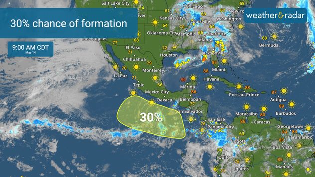
The shaded area denotes the potential formation area of a tropical cyclone over the next 7 days.

Hurricane Center monitors a low pressure system off Mexico's coast, with a 30% chance of development. Starts just before Eastern Pacific hurricane season.

The National Hurricane Center (NHC) issued a tropical weather outlook on Monday, noting the formation of a low pressure system off the southwest coast of Mexico in the Eastern Pacific Ocean.

This development occurs just one day ahead of the official start of the Eastern Pacific hurricane season, which begins on May 15.

An extremely active 2024 season?read also
Privacy policy

Forecasters expect the low pressure to form along a trough several hundred miles south of the Gulf of Tehuantepec by mid to late week. It is predicted to move slowly in a west-northwest direction, remaining well south of the Mexican coast into early next week.

The NHC assesses a 30% chance of further development over the next seven days. Despite its early formation, the system does not currently pose a threat to the United States and is expected to stay offshore of Mexico.

Federico Di Catarina
More on the topic
Super Typhoon Bavi threatens Taiwan. 155 mph winds. . Weather Videos. Wednesday, July 8, 2026
The image shows an intense tropical cyclone over the western Pacific, east of Taiwan and the Philippines. The centre of the system is depicted as a light purple and white vortex with a clearly visible eye, surrounded by a ring of red and orange areas indicating the strongest wind speeds. A white arrow marks the typhoon’s predicted track towards the north-west, in the direction of Taiwan. To the west of the storm lie the Philippines, with the cities of Manila and Cebu; to the north of these lies Taiwan, with Taipei. Further west, the Chinese coast, including Hong Kong, and parts of Vietnam can be seen. The coloured wind map shows predominantly green areas outside the storm’s core, indicating significantly weaker winds. White streamlines illustrate the typhoon’s anti-clockwise circulation in the Northern Hemisphere. The highest wind speeds are concentrated around the eye of the cyclone.
Weather VideosWednesday, July 8, 2026

155 mph winds

Super Typhoon Bavi threatens Taiwan
Waterspouts possible, what are they?. They can be dangerous. . . Sunday, August 9, 2026
Waterspouts weatherradar.
Sunday, August 9, 2026

They can be dangerous

Waterspouts possible, what are they?
The best views of Wednesday's eclipse. Europe's sky show. . . Thursday, August 13, 2026
Solar eclipse: The sun obscured between wind turbines in Sardinia
Thursday, August 13, 2026

Europe's sky show

The best views of Wednesday's eclipse
All weather news
This might also interest you
Days of record nighttime heat. Feeling tropical. . . Monday, August 17, 2026
Monday, August 17, 2026

Feeling tropical

Days of record nighttime heat
Tornado producer brings fall refresh. Northeast low. . . Friday, August 21, 2026
Friday, August 21, 2026

Northeast low

Tornado producer brings fall refresh
Wildfire explodes to 15k+ acres. Air quality concerns. . . Monday, August 24, 2026
Monday, August 24, 2026

Air quality concerns

Wildfire explodes to 15k+ acres
All articles
Weather & Radar

Weather & Radar is also available on

Google Play StoreApp Store

Company

Contact us Privacy policy Legal info Accessibility statement

Services

Uploader

Socials

instagramfacebookthreadslinkList