Home
Weather New York
WeatherRadar
RainRadar
TemperatureRadar
WindRadar
LightningRadar
Weather News
Editor's Pick
Discover the app
Weather widget
Contact us
Apps
Career
    Home / Editor's Pick /

    Major Hurricane Beryl - Category 5 racing over the Caribbean

12:08 PM
July 2, 2024

Major Hurricane Beryl
Category 5 racing over the Caribbean

Major Hurricane Beryl continues to break records. It briefly reached category 5 status in the Caribbean, making it the earliest category 5 hurricane to form in Atlantic Basin history.

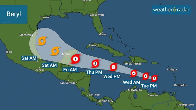
On Tuesday morning, Beryl holds maximum sustained winds of 165 mph and moves west-northwest at 22 mph racing toward Jamaica where the hurricane is expected to come on or very close to on Wednesday late morning.

Beryl Track

It will continue to be a major hurricane, likely a strong category 3 with 120 mph and bringing major storm surge to the island. Storm surge also remains a big threat to the southern coast of Hispaniola and Puerto Rico.

Tuesday will be a day at sea for Beryl, traveling over very warm waters currently running between 1 and 2.5C above normal. These are mid-September’s water temperatures.. but in early July! This will continue to serve as prime fuel for Beryl to keep its strength through Wednesday evening.

Once Beryl passes Jamaica, its strength forecasts are highly uncertain. Water temperatures are running about 1.5 C above normal, but there could also be wind shear denting the system and dry air tapping into it, which could serve as a choking mechanism. There is also Jamaica’s high terrain that could give the storm another punch.

Keep in mind that this storm’s forward speed is relatively fast, so the high terrain might not do much, especially if the system remains over water and doesn’t make landfall in Jamaica. Southeastern Mexico should prepare for at least a category 2 hurricane, but keep in mind that this system could arrive stronger.

Irene Sans
More on the topic
All about nocturnal severe weather. Risks & preparedness. . . Saturday, September 5, 2026
Saturday, September 5, 2026

Risks & preparedness

All about nocturnal severe weather
Record ocean heat halting hurricanes. Strong El Niño influence. . . Sunday, September 13, 2026
A weather map shows a calm Atlantic Ocean with no hurricanes, alongside a picture of the sea.
Sunday, September 13, 2026

Strong El Niño influence

Record ocean heat halting hurricanes
Hurricane parade in the Pacific. Karina is very strong. . Weather Videos. Tuesday, September 1, 2026
WindRadar for Friday, showing the three hurricanes – Lowell, Karina and Maria – over the Pacific.
Weather VideosTuesday, September 1, 2026

Karina is very strong

Hurricane parade in the Pacific
All weather news
This might also interest you
October astro outlook. Look up!. . . Saturday, October 3, 2026
Star gazing - Astro outlook
Saturday, October 3, 2026

Look up!

October astro outlook
Merging storms to bring record rain. Southwest, Plains. . . Tuesday, September 29, 2026
Heavy rainfall is expected across the Plains and Southwest, with flash flooding possible.
Tuesday, September 29, 2026

Southwest, Plains

Merging storms to bring record rain
Rounds of rain for Florida. Not so Sunshine State. . . Monday, October 5, 2026
While October typically marks a transition to drier weather in Florida, the first full week of the month is kicking off with heavy rain. But how much rain are we talking about?
Monday, October 5, 2026

Not so Sunshine State

Rounds of rain for Florida
All articles
Weather & Radar

Weather & Radar is also available on

Google Play StoreApp Store

Company

Contact us Privacy policy Legal info Accessibility statement

Services

Uploader

Socials

instagramfacebookthreadslinkList