Home
Weather New York
WeatherRadar
RainRadar
TemperatureRadar
WindRadar
LightningRadar
Weather News
Editor's Pick
Discover the app
Weather widget
Contact us
Apps
Career
    Home / Editor's Pick /

    Major Hurricane Beryl - Category 5 racing over the Caribbean

12:08 PM
July 2, 2024

Major Hurricane Beryl
Category 5 racing over the Caribbean

Major Hurricane Beryl continues to break records. It briefly reached category 5 status in the Caribbean, making it the earliest category 5 hurricane to form in Atlantic Basin history.

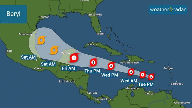
On Tuesday morning, Beryl holds maximum sustained winds of 165 mph and moves west-northwest at 22 mph racing toward Jamaica where the hurricane is expected to come on or very close to on Wednesday late morning.

Beryl Track

It will continue to be a major hurricane, likely a strong category 3 with 120 mph and bringing major storm surge to the island. Storm surge also remains a big threat to the southern coast of Hispaniola and Puerto Rico.

Tuesday will be a day at sea for Beryl, traveling over very warm waters currently running between 1 and 2.5C above normal. These are mid-September’s water temperatures.. but in early July! This will continue to serve as prime fuel for Beryl to keep its strength through Wednesday evening.

Once Beryl passes Jamaica, its strength forecasts are highly uncertain. Water temperatures are running about 1.5 C above normal, but there could also be wind shear denting the system and dry air tapping into it, which could serve as a choking mechanism. There is also Jamaica’s high terrain that could give the storm another punch.

Keep in mind that this storm’s forward speed is relatively fast, so the high terrain might not do much, especially if the system remains over water and doesn’t make landfall in Jamaica. Southeastern Mexico should prepare for at least a category 2 hurricane, but keep in mind that this system could arrive stronger.

Irene Sans
More on the topic
How does fog form?. Multiple ways. . . Saturday, September 12, 2026
Saturday, September 12, 2026

Multiple ways

How does fog form?
Meteorological vs astronomical autumn. Season start date. . . Tuesday, September 1, 2026
Tuesday, September 1, 2026

Season start date

Meteorological vs astronomical autumn
Hurricane parade in the Pacific. Karina is very strong. . Weather Videos. Tuesday, September 1, 2026
WindRadar for Friday, showing the three hurricanes – Lowell, Karina and Maria – over the Pacific.
Weather VideosTuesday, September 1, 2026

Karina is very strong

Hurricane parade in the Pacific
All weather news
This might also interest you
Why do leaves change their colors?. Autumn splendor. . . Saturday, September 26, 2026
White Mountain National Forest, New Hampshire in autumn.
Saturday, September 26, 2026

Autumn splendor

Why do leaves change their colors?
Autumn cold front arrives. October cooldown spreads. . . Friday, October 2, 2026
Cold front brings cooler temperatures.
Friday, October 2, 2026

October cooldown spreads

Autumn cold front arrives
12+ foot waves, gusty winds. Season's first Nor'easter. . . Wednesday, September 23, 2026
Wednesday, September 23, 2026

Season's first Nor'easter

12+ foot waves, gusty winds
All articles
Weather & Radar

Weather & Radar is also available on

Google Play StoreApp Store

Company

Contact us Privacy policy Legal info Accessibility statement

Services

Uploader

Socials

instagramfacebookthreadslinkList