Home
Weather New York
WeatherRadar
RainRadar
TemperatureRadar
WindRadar
LightningRadar
Weather News
Editor's Pick
Discover the app
Weather widget
Contact us
Apps
Career
    Home / Editor's Pick /

    Major Hurricane Beryl - Jamaica faces dangerous storm surge

02:44 PM
July 3, 2024

Major Hurricane Beryl
Jamaica faces dangerous storm surge

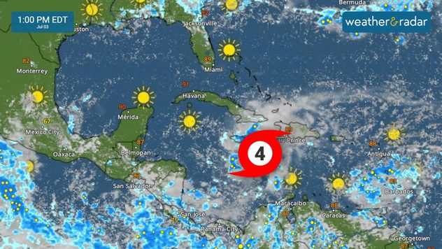
WeatherRadar as Category 4 Beryl inches closer to Jamaica Wednesday.

Beryl’s force arrives in Jamaica today causing a life-threatening storm surge. The system battles dry air and rough terrain, and the intensity forecast remains highly uncertain for the Yucatán Peninsula and beyond.

Privacy policy

Major Hurricane Beryl is still a category 4 storm quickly approaching Jamaica, where it should make landfall on Wednesday. It is moving west-northwest at 20 mph and is expected to remain a major hurricane at the same speed and general direction as it moves across Jamaica on Wednesday and the Cayman Islands through Thursday. By Friday it should reach the Yucatán Peninsula.

The big questions remain: How strong will it be when it arrives in Southeast Mexico and what will happen after it emerges over the Gulf of Mexico early Saturday?

Beryl will battle with dry air between Wednesday and Friday, and with some of Jamacia's high terrain. But warm waters, running about 1C above average, continue to serve as prime fuel for this system to continue to be strong. This is why we urge residents and visitors along the southeastern coast of the Yucatán Peninsula to please prepare for at least a category 3 hurricane, one category above what's forecasted to impact (under Wednesday's forecast)Everyone should be in place by Thursday night in Southeast Mexico.

Many residents are asking about a possible U.S. strike early next week. As of now, there is high uncertainty about the track. We must wait to see what conditions will be in place as this system exits the Caribbean and the Yucatán Peninsula. It is clear now that the system will likely become larger, which could bring storm surge along the Texas Coast even if it stays along a Mexican track for landfall. As of now, the heaviest rain is slated for South Texas, but remember there will be changes. Please check back for more information in the coming days.

Irene Sans
More on the topic
Waterspouts possible, what are they?. They can be dangerous. . . Saturday, July 11, 2026
Waterspouts weatherradar.
Saturday, July 11, 2026

They can be dangerous

Waterspouts possible, what are they?
How does fog form?. Multiple ways. . . Saturday, July 11, 2026
Saturday, July 11, 2026

Multiple ways

How does fog form?
Longest day of the year is here. Summer solstice. . . Sunday, June 21, 2026
Sunday, June 21, 2026

Summer solstice

Longest day of the year is here
All weather news
This might also interest you
Lopsided Bertha moves west. Who sees the impacts. . . Thursday, July 23, 2026
Thursday, July 23, 2026

Who sees the impacts

Lopsided Bertha moves west
Temps 15-degrees below average. Big cold front. . . Wednesday, July 22, 2026
Wednesday, July 22, 2026

Big cold front

Temps 15-degrees below average
How does a hurricane form?. Hurricane preparedness. . . Sunday, July 19, 2026
hurricane maria
Sunday, July 19, 2026

Hurricane preparedness

How does a hurricane form?
All articles
Weather & Radar

Weather & Radar is also available on

Google Play StoreApp Store

Company

Contact us Privacy policy Legal info Accessibility statement

Services

Uploader

Socials

instagramfacebookthreadslinkList