Home
Weather New York
WeatherRadar
RainRadar
TemperatureRadar
WindRadar
LightningRadar
Weather News
Editor's Pick
Discover the app
Weather widget
Contact us
Apps
Career
    Home / Weather News /

    May Gray and June Gloom

06:57 PM
March 18, 2026

The marine layer
May Gray and June Gloom

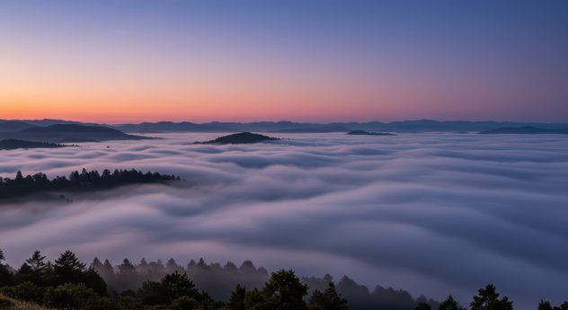
Wide, panoramic shot taken from a high vantage point overlooking a vast expanse of thick, rolling fog or low-lying clouds filling a valley just before sunrise or after sunset. Silhouetted dark evergreen trees line the foreground and punctuate the cloud sea, with distant, layered mountain ridges visible beneath a colorful sky displaying soft gradients of blue, purple, and faint orange near the horizon.
Marine layer composed of low clouds and fog. - © Adobe Stock

Sometimes called "natures air conditioner," marine layer fog plays a significant role in keeping coastal communities along the West Coast comfortable in the late spring and early summer.

If you take a look at the West Coast on the WeatherRadar in the late spring or early summer, there's a good chance you'll see dense low-hanging clouds and fog along the coast. This is referred to as the marine layer.

A marine layer is a shallow, cool, moist air mass that forms over the ocean and drifts inland, frequently producing low clouds, fog, and cool temperatures along coastal areas during spring and summer. While it is common to see this phenomenon in late spring and early summer, it can occur at any time of year. However, the terms "June Gloom" and "May Gray" refer to the frequent presence of the marine layer at this time of year.

Privacy policy

The marine layer helps keep temperatures mild and supports ecosystems on the Pacific coast. It provides moisture for plants like redwoods and acts like a natural air conditioner. It’s usually thickest at sunrise and often clears up by the afternoon as the sun warms the land.

Mary Mays
More on the topic
Hurricane parade in the Pacific. Karina is very strong. . Weather Videos. Tuesday, September 1, 2026
WindRadar for Friday, showing the three hurricanes – Lowell, Karina and Maria – over the Pacific.
Weather VideosTuesday, September 1, 2026

Karina is very strong

Hurricane parade in the Pacific
How does fog form?. Multiple ways. . . Saturday, September 12, 2026
Saturday, September 12, 2026

Multiple ways

How does fog form?
Record ocean heat halting hurricanes. Strong El Niño influence. . . Sunday, September 13, 2026
A weather map shows a calm Atlantic Ocean with no hurricanes, alongside a picture of the sea.
Sunday, September 13, 2026

Strong El Niño influence

Record ocean heat halting hurricanes
All weather news
This might also interest you
Waves of rain for the Midwest, Plains. Ocean-like pattern. . . Tuesday, September 15, 2026
Think of the atmosphere like an ocean, with waves constantly moving through it. This week, those waves will bring rounds of rain from the southern Rockies into the Plains, Midwest and Missouri Valley.
Tuesday, September 15, 2026

Ocean-like pattern

Waves of rain for the Midwest, Plains
What is it, and why is it important?. North American Monsoon. . . Sunday, September 6, 2026
Desert thunderstorm
Sunday, September 6, 2026

North American Monsoon

What is it, and why is it important?
Dry vegetation, low humidity and winds. The perfect fire recipe. . . Saturday, September 5, 2026
Saturday, September 5, 2026

The perfect fire recipe

Dry vegetation, low humidity and winds
All articles
Weather & Radar

Weather & Radar is also available on

Google Play StoreApp Store

Company

Contact us Privacy policy Legal info Accessibility statement

Services

Uploader

Socials

instagramfacebookthreadslinkList