Home
Weather New York
WeatherRadar
RainRadar
TemperatureRadar
WindRadar
LightningRadar
Weather News
Editor's Pick
Discover the app
Weather widget
Contact us
Apps
Career
    Home / Weather News /

    Midwestern blizzard, southern tornadoes
03:11 PM
January 12, 2024

Friday's live blog
Midwestern blizzard, southern tornadoes

Live updates on this winter storm are bein brought all day Friday.

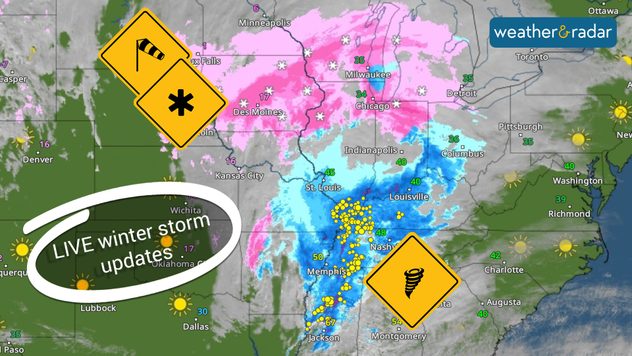
A large winter storm is impacting many from the Midwest south and eastward bringing blizzard conditions, severe storms, and flooding rainfall, just days after the previous winter storm blasted the eastern half. This live blog will be updated throughout the day on Friday to note the latest updates.

4:30 p.m.

Weather & Radar's Jonathan Petramala is in Davenport, Iowa, as blizzard conditions wreak havoc on the roads. Residents of the Quad Cities are encouraged to stay home if possible.

4:00 p.m.

Snow continues to pile up across the Midwest. The Chicago metro has picked up 3-6 inches, while a few communities in Iowa and Wisconsin have snow totals already at or more than a foot.

3:00 p.m.

The Storm Prediction Center has received 33 filtered reports of wind damage since midnight across southeastern Arkansas, northeastern Louisiana, and into northern Mississippi. With winds still gusting in excess of 50 mph, it's important to tie down loose outdoor items.

2:00 p.m.

Flight cancellations continue to rise at several major airports. There have been more than 400 canceled and nearly 200 delayed flights at Chicago's O'Hare International, with 140 canceled and 26 delayed at Chicago's Midway Airport. M​ore than 300 flights have been canceled or delayed at Denver International and more than 50 at Milwaukee Mitchell International Airport.

12:45 p.m.

Meteorologist Becca Parker will be live on YouTube at 1 p.m. ET, covering the latest on the powerful winter storm. Click the video below to watch.

12:30 p.m.

Snow totals over the last 24 hours vary, with Finland, Minn., which is just off Lake Superior, picking up 17 inches. This event is ongoing, and these totals will continue growing for many communities. So far, the city of Chicago has picked up between 1 and 3 inches of snow, with the northern and western suburbs seeing 3 to 8 inches on the ground.

12:00 p.m.

Road conditions in Iowa continue to deteriorate with parts of I-80's eastbound lane shut down near Victor. Avoid traveling unless it's absolutely necessary.

11:30 a.m.

Power outages are growing as this massive storm continues to impact the eastern half of the U.S. Here are the numbers of customers without power in states impacted by this system.

  • Illinois- 80,710
  • Texas- 50,797
  • Wisconsin- 22,791
  • Arkansas- 19,644
  • Tennessee- 18.020

10:30 a.m.

Winds are gusting up to 55 mph outside of thunderstorms across the South this morning. Keep up with these powerful gusts on the WindRadar.

9:30 a.m.

More than 1,000 flights are grounded nationwide due to treacherous conditions from the blizzard conditions in the Midwest. Chicago O'Hare holds 700 of those grounded flights.

Iowa is also seeing winter storm delays. Many are having snow days this Friday!

Weather & Radar USA editorial team
More on the topic
How does fog form?. Multiple ways. . . Saturday, September 12, 2026
Saturday, September 12, 2026

Multiple ways

How does fog form?
Record ocean heat halting hurricanes. Strong El Niño influence. . . Sunday, September 13, 2026
A weather map shows a calm Atlantic Ocean with no hurricanes, alongside a picture of the sea.
Sunday, September 13, 2026

Strong El Niño influence

Record ocean heat halting hurricanes
What are weather fronts?. Weather explained. . . Sunday, August 23, 2026
Image of a temperature radar showing a clear distinction between a warm and cold air mass separated by a cold front.
Sunday, August 23, 2026

Weather explained

What are weather fronts?
All weather news
This might also interest you
12+ foot waves, gusty winds. Season's first Nor'easter. . . Wednesday, September 23, 2026
Wednesday, September 23, 2026

Season's first Nor'easter

12+ foot waves, gusty winds
Beautiful autumn sky. Your weather — Your shots. . . Saturday, September 19, 2026
Saturday, September 19, 2026

Your weather — Your shots

Beautiful autumn sky
30-degree drop on heels of equinox. Mid-Atlantic & Southeast. . . Monday, September 21, 2026
Monday, September 21, 2026

Mid-Atlantic & Southeast

30-degree drop on heels of equinox
All articles
Weather & Radar

Weather & Radar is also available on

Google Play StoreApp Store

Company

Contact us Privacy policy Legal info Accessibility statement

Services

Uploader

Socials

instagramfacebookthreadslinkList