Home
Weather New York
WeatherRadar
RainRadar
TemperatureRadar
WindRadar
LightningRadar
Weather News
Editor's Pick
Discover the app
Weather widget
Contact us
Apps
Career
    Home / Weather News /

    Monday's live blog: Severe threat ramps up for the South

02:48 PM
May 13, 2024

Monday's live blog
Severe threat ramps up for the South

Powerful severe storms impacted the northern Gulf Coast on Monday. This live brought you the latest updates throughout Monday.

4:45 p.m. CDT

Flooding was also an issue earlier today in Panama City Beach, Fla.

3:00 p.m. CDT

Gusty winds rocked through Panama City Beach, Fla., earlier today. While the storms that brought the wind have pushed off the Panhandle, strong storms are expected to continue into the afternoon and afternoon across parts of the peninsula.

1:30 p.m. CDT

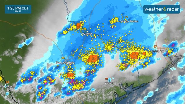
Storms are firing up across central and southern Texas, bringing gusty winds and hail to the Austin, San Antonio and Houston areas.

WeatherRadar

12:30 p.m. CDT

A tornado watch is in effect until 7:00 p.m. EDT for parts of the Florida Panhandle. Now is a good time to make sure your app alerts are turned on.

11:15 a.m. CDT

In Pensacola, Fla., police have advised people to avoid flooded areas after two vehicles stalled out on flooded roads. Flooding has been reported at numerous intersections.

10:30 a.m. CDT

Strong storms with powerful wind gusts are baring down on the northern Gulf Coast. Keep an eye on the WeatherRadar before heading out.

9:45 a.m. CDT

Monday's severe weather puts more than 15 million people at risk from central Texas through the Florida Panhandle. An enhanced risk, a level three out of five of severe weather, extends along the northern Gulf Coast.

Weather & Radar USA editorial team
More on the topic
Super Typhoon Near the Philippines. Gusts up to 155. . . Tuesday, June 23, 2026
Tuesday, June 23, 2026

Gusts up to 155

Super Typhoon Near the Philippines
Super Typhoon Bavi threatens Taiwan. 155 mph winds. . Weather Videos. Wednesday, July 8, 2026
The image shows an intense tropical cyclone over the western Pacific, east of Taiwan and the Philippines. The centre of the system is depicted as a light purple and white vortex with a clearly visible eye, surrounded by a ring of red and orange areas indicating the strongest wind speeds. A white arrow marks the typhoon’s predicted track towards the north-west, in the direction of Taiwan. To the west of the storm lie the Philippines, with the cities of Manila and Cebu; to the north of these lies Taiwan, with Taipei. Further west, the Chinese coast, including Hong Kong, and parts of Vietnam can be seen. The coloured wind map shows predominantly green areas outside the storm’s core, indicating significantly weaker winds. White streamlines illustrate the typhoon’s anti-clockwise circulation in the Northern Hemisphere. The highest wind speeds are concentrated around the eye of the cyclone.
Weather VideosWednesday, July 8, 2026

155 mph winds

Super Typhoon Bavi threatens Taiwan
High pressure & extreme heat. Why & how does it work?. . . Sunday, July 12, 2026
Sunday, July 12, 2026

Why & how does it work?

High pressure & extreme heat
All weather news
This might also interest you
6 easy steps to take now to be ready. Hurricane preparedness. . . Sunday, August 9, 2026
Are you ready?
Sunday, August 9, 2026

Hurricane preparedness

6 easy steps to take now to be ready
When severe storms strike.... You can be ready. . . Monday, August 10, 2026
Monday, August 10, 2026

You can be ready

When severe storms strike...
Watch storm clusters interact. A busy WeatherRadar. . . Tuesday, August 11, 2026
Tuesday, August 11, 2026

A busy WeatherRadar

Watch storm clusters interact
All articles
Weather & Radar

Weather & Radar is also available on

Google Play StoreApp Store

Company

Contact us Privacy policy Legal info Accessibility statement

Services

Uploader

Socials

instagramfacebookthreadslinkList