Home
Weather New York
WeatherRadar
RainRadar
TemperatureRadar
WindRadar
LightningRadar
Weather News
Editor's Pick
Discover the app
Weather widget
Contact us
Apps
Career
    Home / Editor's Pick /

    North Texas in bullseye Severe storms to linger, increase flooding risk too

03:28 PM
May 22, 2024

North Texas in bullseye
Severe storms linger, higher flood risk

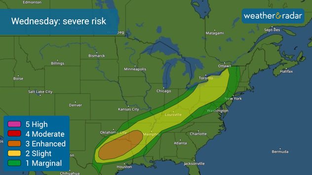
After a horrific night across much of Iowa and Wisconsin, the severe storm risk now shifts south. Over 10 million people, mainly across Texas, including the Metroplex area are at risk of experiencing several tornadoes, large hail, and damaging winds of at least 80 mph. Let’s dive into the forecast.

The northern portion of the Metroplex, north of I-20 from Gainesville to Paris, can expect the first rounds of thunderstorms to arrive late morning into the early afternoon. Severe storms will likely move over the I-20 corridor around 2 p.m., and migrate slowly southward and dominate I-35 through Waco until around midnight. In the evening there could still be a few strong to severe storms east of Dallas from Paris to Palestine.

Severe weather risk for Wednesday

The main threat with the storms will be large hail and damaging winds, but a few tornadoes cannot be ruled out. Make sure to have several ways of receiving weather alerts, stay in a safe place, and seek safe shelter as soon as a warning is issued for your location.

The next threat is flooding. Several rounds of storms and showers will continue in a not-so-organized way on Thursday, with conditions improving gradually on Friday but with clouds still on the way. The forecast calls for rainfall totals between 1 to 3 inches but some isolated areas could receive 5 inches. Remember to run around, don’t drown. Thursday’s storms will mainly come in the afternoon and evening and the morning will be more under scattered showers.

Flood risk: how much?

About 20% of the locations under a flood watch will receive over 4 inches of rain.

The slight risk, level 2 of 5 in the severity scale extends to the Northeast across the Ohio Valley. The main threats are damaging winds, followed by hail. But there is a spot focused over eastern Ohio and western Pennsylvania, including Cleveland, and surroundings where a tornado could develop.

There will be several more systems exiting the Rockies throughout the weekend, but it seems like they will not travel south too much and stay stuck over the central plains moving eastward over the Midwest, Ozarks, and Great Lakes area. We will bring you updates throughout the day on our live blog and social media channels. Stay informed and tell your family and friends in threatened areas.

Irene Sans
More on the topic
The best views of Wednesday's eclipse. Europe's sky show. . . Thursday, August 13, 2026
Solar eclipse: The sun obscured between wind turbines in Sardinia
Thursday, August 13, 2026

Europe's sky show

The best views of Wednesday's eclipse
What are weather fronts?. Weather explained. . . Sunday, August 23, 2026
Image of a temperature radar showing a clear distinction between a warm and cold air mass separated by a cold front.
Sunday, August 23, 2026

Weather explained

What are weather fronts?
Hurricane parade in the Pacific. Karina is very strong. . Weather Videos. Tuesday, September 1, 2026
WindRadar for Friday, showing the three hurricanes – Lowell, Karina and Maria – over the Pacific.
Weather VideosTuesday, September 1, 2026

Karina is very strong

Hurricane parade in the Pacific
All weather news
This might also interest you
More than 20 inches of rain from Edouard. Possible drought help?. . . Thursday, September 3, 2026
Thursday, September 3, 2026

Possible drought help?

More than 20 inches of rain from Edouard
Southwest flood risk. Brief triple-digit break. . . Monday, August 31, 2026
Desert Southwest
Monday, August 31, 2026

Brief triple-digit break

Southwest flood risk
Why are some sunsets so beautiful?. And why are some duds?. . . Sunday, September 6, 2026
Credit Mark Maxwell - St Joseph, Mich.
Sunday, September 6, 2026

And why are some duds?

Why are some sunsets so beautiful?
All articles
Weather & Radar

Weather & Radar is also available on

Google Play StoreApp Store

Company

Contact us Privacy policy Legal info Accessibility statement

Services

Uploader

Socials

instagramfacebookthreadslinkList